Wednesday, July 5, 2006
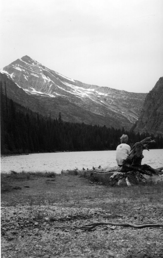
Avalanche Lake view
Brian took this photo. It was taken at the head of Avalanche Lake in Glacier Nat'l Park. Yes, that is me. I am wearing my "surf patrol | Apple computers" tshirt. Brian is a big Apple computer fan so he had to have a photo.

Tuesday, July 4, 2006
Hidden Avalanche Bear
Thursday Brian and I didn't leave for Glacier Park until the afternoon.
When driving along Lake McDonald we seen a Park ranger had stopped a teenage girl on a bicycle. She was bicycling in a no bicycling zone at 3:30 pm. Along Lake McDonald bicycling is not allowed from 9 am - 4 pm. From the Avalanche area to Logan Pass bicycling is not allowed from 11 to 4 pm. I didn't see any "no bicycling" signs east of Logan Pass.
Avalanche
The main purpose of visiting the Avalanche area was for Brian to re-shoot some photos of the Avalanche Gorge. Since we were here he decided we should hike the 2 miles (one way) to Avalanche Lake. The lake has a great view as one can see along the cirque seven waterfalls that eventually make their way to Avalanche Lake.
After a short stop at the foot of the lake to rest and take photos we continued on the trail to the head of the lake. We met a bicyclist in full dress. I asked where his bicycle was. Of course bicycles are not allowed on the trails. He had left it and his clipless shoes at the start of the trail. He was hiking in a spare pair of shoes. Now this is my way to travel: bike and hike.
At the far end of lake were two men, a woman, and one of the men's young son. They were all fishing for cutthroat trout or Brookies in the lake. At least that is what they told me. They cast and reeled their fishing lines and never got anything. The dad had taken his shoes and socks off in order to cross one of the streams (the SE one) to go to fish where the east stream entered the lake. He carried his son across the stream with him.
The son, typical child, wasn't sure where he wanted to fish and had to jump smaller streams between the larger ones as dad was too busy fishing to stop to carry his son over the smaller streams. The boy was able to jump the streams without getting wet - somehow.
At one point the woman tried to use her cell phone. *sheesh* We are in the middle of Glacier Park, between tall mountains at the far end of a narrow valley at the bottom of a cirque and she thinks a cell phone will work?
Brian took his shoes off to ford the streams to get various photos. I sat on a huge tree trunk and watched everyone. Sometimes it is nice not to have a camera.
After Brian's photo taking I convinced him to hike on the unmaintained trail past the lake. This trail goes past the pine trees and comes out near where the snowfields and streams from the waterfall pass. Brian was reluctant and I had to keep with the encouragement as the trail went up and down and over fallen trees. Just when Brian wouldn't go further I came out the end of the trail into the open area.
I had hiked this same trail with Francis's wife, Linda, last year when the snow came further down the cirque. We were able to hike to the snow. This year there was less snow and the small deciduous trees created a barrier between us and the snow.
 As I looked at the trees then the waterfalls Brian exclaimed excitedly that he saw a bear. Part way up the cirque between two streams and near a snowfield a bear was wandering. It was probably a quarter mile away, too far to make out if it was a black bear or a grizzly.
Brian has almost always seen a bear when he visited Glacier Park in the past while I only seen one bear in all the times I visited the Park. Brian has no interest in seeing another bear and grumbled that 'he knew this would happen'; that it was a mistake to hike on this trail past the lake.
While he told me this he also asked me to hold this camera's lens cap while he took photos. I asked if he could tell what type of bear it was from his telephoto but he couldn't. He quickly took photos while I watched the bear move. That is why the photo is a little out of focus.
After taking a few photos Brain quickly put his camera back into its bag. Brian wanted to leave - immediately.
The bear was slowly wandering NE along the rocks so I didn't feel the need to leave so soon. I wanted to watch the bear some more but Brian wouldn't leave without me and was very nervous staying here so we left.
At the lake Brian and I told the people about the bear. When one guy got his binoculars to look for the bear that is when I remembered I had my binoculars in my small backpack with me. I forgot I had them with me.
We couldn't see the bear from the lake. The view wasn't quite the same as from the end of the trail, and the bear may have wandered into the scattered trees that grew near where he was when we had seen them.
It was getting later now so we skipped eating and drove directly to Logan Pass. During the drive to Logan Pass we noticed the large rock that had been balanced at the edge of a snowbank along Going-to-the-Sun road was now on the side of the road. It appeared the Park had used a machine to get the rock down before it fell on someone, a car, or damaged the road. Brian and I had been watching the rock each day to see how long it remained on the melting snowbank.
All day we had seen less than the usual amount of cars and people and Logan's Pass was no different. It was a little after 7 pm so the visitors center was closed and the rangers were collecting the trash and locking up.
A male bighorn sheep on was on the stone steps to the visitors center and was licking the wet steps. People were buzzing about in order to get photos.
Turns out the Park had washed the step with water and bleach. While sheep and mountain goats lick anti-freeze to no ill effect, the Park doesn't want them to do so. A male and female ranger came back and shooed the sheep off the steps. The sheep did not move far and would move to return to the steps when the rangers backed off. Finally the woman ranger shouted forcefully and clapped her hands and the sheep wandered off.
Before the rangers started to chase off the sheep Brian told the male ranger we had seen a bear. The ranger was interested and asked for us to tell him more after he chased the sheep away. After the sheep left a woman came up to the male ranger and asked him where the bears were. She pointed, "Over there?" Some people...
More people asked him dumb questions, then he had to put something away. I told Brian the sun would be setting soon and if he wanted to return before dark we needed to get a move on. He agreed and we left. The next day Brian found a ranger and reported the bear we had seen.
The trail to the Hidden Lake overlook was entirely snow covered. The sun was behind high clouds, and while it was near 90 F in the Valley, it was very cool here. I came prepared and put on my flannel shirt then light coat. Over my shoes I wore rubber overshoes to keep my feet dry. "Ready? Let's go!"
Shortly we met a young couple with southern accents. Not only had they hiked the 1.5 miles to the Hidden Lake overlook, they also hiked down to Hidden Lake, which was another 1.5 miles. They both looked very tired, especially as they had done another 6 mile hike earlier in the day.
Then we met a middle aged man with a "Maybe it wasn't such a good idea" tshirt. I asked if that applied to this hike. He laughed and said maybe.
From below I could see four people on the narrow bend with the steep drop-off. They were moving slowly crouching low with one hand on the upper snow bank. When we encountered them I found the two men and two women looked and sounded Japanese.
On the steep bend we met a young man and woman. The woman told us with wide eyes about the mountains goats further up the trail. She afraid of them and their horns and thought they got too close to her. She said she tried to hide behind small trees while he took photos but they would follow her.
They were the last people we seen on the trail. We had the overlook to ourselves - except for the four or five mountain goats roaming the boardwalk and overlook. The small one was already shedding her winter coat. At one point she rubbed to get more fur off. She then laid down and tilted her head back to use her horns to scratch some more.
I set my small bag down to get food to eat as I looked over the partially frozen and snow covered Hidden Lake. I left my bag to look for the sign with the distance to Hidden Lake. Then I walked over the snow covered trail to look for the point where the trail left the mountain saddle and started down the valley to Hidden Lake. There was lots of snow, and past the overlook the Park had not stuck markers in the snow to show where the trail was.
I saw a marmot wandering around a green patch of land. I noticed the snow had melted away from the very large rocks along the trail - even on the north side of the rocks. Eventually I quit and returned to the overlook.
When I had left the overlook I shouted back at Brian to watch my bag so no mountain goat got it. He hadn't heard me, but while taking photos of the goats he saw several go for my bag and he rescued it. Brian took lots of photos of the goats. I even posed by a few of them.
Having taken his photos Brian didn't want to linger longer. He didn't want to hike back in the dark. He also had plans on getting up early the next morning to take sunrise photos of the mountains.
Shortly after we started back it began to lightly rain. The end of June and we were walking over a large snowfield in the rain.
Near the visitors center the bright yellow wildflowers covered the green meadow areas where the snow had recently melted. They were partially curled up as they were in the shadow of Mt. Oberlin.
It was after 9 pm and Brian's car was the only car in the parking lot. The bighorn sheep was back licking the steps. As we walked by he jumped up off the steps and moved a short distance away. He returned to the steps as we went to the parking lot.
Even with the light rain the clouds over the mountain tops to the NW were a little pastel pink. Pretty.
It rained all the way home, sometimes heavier than others. We got home at 11:30 pm. Late, as Brian planned to get up in time to drive to the park to catch the sunrise. I wasn't going since it was too early for me.
When driving along Lake McDonald we seen a Park ranger had stopped a teenage girl on a bicycle. She was bicycling in a no bicycling zone at 3:30 pm. Along Lake McDonald bicycling is not allowed from 9 am - 4 pm. From the Avalanche area to Logan Pass bicycling is not allowed from 11 to 4 pm. I didn't see any "no bicycling" signs east of Logan Pass.
Avalanche
The main purpose of visiting the Avalanche area was for Brian to re-shoot some photos of the Avalanche Gorge. Since we were here he decided we should hike the 2 miles (one way) to Avalanche Lake. The lake has a great view as one can see along the cirque seven waterfalls that eventually make their way to Avalanche Lake.
After a short stop at the foot of the lake to rest and take photos we continued on the trail to the head of the lake. We met a bicyclist in full dress. I asked where his bicycle was.
 Of course bicycles are not allowed on the trails. He had left it and his clipless shoes at the start of the trail. He was hiking in a spare pair of shoes. Now this is my way to travel: bike and hike.
At the far end of lake were two men, a woman, and one of the men's young son. They were all fishing for cutthroat trout or Brookies in the lake. At least that is what they told me. They cast and reeled their fishing lines and never got anything. The dad had taken his shoes and socks off in order to cross one of the streams (the SE one) to go to fish where the east stream entered the lake. He carried his son across the stream with him.
The son, typical child, wasn't sure where he wanted to fish and had to jump smaller streams between the larger ones as dad was too busy fishing to stop to carry his son over the smaller streams. The boy was able to jump the streams without getting wet - somehow.
At one point the woman tried to use her cell phone. *sheesh*
 We are in the middle of Glacier Park, between tall mountains at the far end of a narrow valley at the bottom of a cirque and she thinks a cell phone will work?
Brian took his shoes off to ford the streams to get various photos. I sat on a huge tree trunk and watched everyone. Sometimes it is nice not to have a camera.
After Brian's photo taking I convinced him to hike on the unmaintained trail past the lake. This trail goes past the pine trees and comes out near where the snowfields and streams from the waterfall pass. Brian was reluctant and I had to keep with the encouragement as the trail went up and down and over fallen trees. Just when Brian wouldn't go further I came out the end of the trail into the open area.
I had hiked this same trail with Francis's wife, Linda, last year when the snow came further down the cirque. We were able to hike to the snow. This year there was less snow and the small deciduous trees created a barrier between us and the snow.
As I looked at the trees then the waterfalls Brian exclaimed excitedly that he saw a bear. Part way up the cirque between two streams and near a snowfield a bear was wandering. It was probably a quarter mile away, too far to make out if it was a black bear or a grizzly.Brian has almost always seen a bear when he visited Glacier Park in the past while I only seen one bear in all the times I visited the Park. Brian has no interest in seeing another bear and grumbled that 'he knew this would happen'; that it was a mistake to hike on this trail past the lake.
While he told me this he also asked me to hold this camera's lens cap while he took photos. I asked if he could tell what type of bear it was from his telephoto but he couldn't. He quickly took photos while I watched the bear move. That is why the photo is a little out of focus.
After taking a few photos Brain quickly put his camera back into its bag. Brian wanted to leave - immediately.
The bear was slowly wandering NE along the rocks so I didn't feel the need to leave so soon. I wanted to watch the bear some more but Brian wouldn't leave without me and was very nervous staying here so we left.
At the lake Brian and I told the people about the bear. When one guy got his binoculars to look for the bear that is when I remembered I had my binoculars in my small backpack with me.
 I forgot I had them with me.
We couldn't see the bear from the lake. The view wasn't quite the same as from the end of the trail, and the bear may have wandered into the scattered trees that grew near where he was when we had seen them.
It was getting later now so we skipped eating and drove directly to Logan Pass. During the drive to Logan Pass we noticed the large rock that had been balanced at the edge of a snowbank along Going-to-the-Sun road was now on the side of the road. It appeared the Park had used a machine to get the rock down before it fell on someone, a car, or damaged the road. Brian and I had been watching the rock each day to see how long it remained on the melting snowbank.
All day we had seen less than the usual amount of cars and people and Logan's Pass was no different. It was a little after 7 pm so the visitors center was closed and the rangers were collecting the trash and locking up.
A male bighorn sheep on was on the stone steps to the visitors center and was licking the wet steps. People were buzzing about in order to get photos.
Turns out the Park had washed the step with water and bleach. While sheep and mountain goats lick anti-freeze to no ill effect, the Park doesn't want them to do so. A male and female ranger came back and shooed the sheep off the steps. The sheep did not move far and would move to return to the steps when the rangers backed off. Finally the woman ranger shouted forcefully and clapped her hands and the sheep wandered off.
Before the rangers started to chase off the sheep Brian told the male ranger we had seen a bear. The ranger was interested and asked for us to tell him more after he chased the sheep away. After the sheep left a woman came up to the male ranger and asked him where the bears were. She pointed, "Over there?" Some people...
More people asked him dumb questions, then he had to put something away. I told Brian the sun would be setting soon and if he wanted to return before dark we needed to get a move on. He agreed and we left. The next day Brian found a ranger and reported the bear we had seen.
The trail to the Hidden Lake overlook was entirely snow covered. The sun was behind high clouds, and while it was near 90 F in the Valley, it was very cool here. I came prepared and put on my flannel shirt then light coat. Over my shoes I wore rubber overshoes to keep my feet dry. "Ready? Let's go!"
Shortly we met a young couple with southern accents. Not only had they hiked the 1.5 miles to the Hidden Lake overlook, they also hiked down to Hidden Lake, which was another 1.5 miles. They both looked very tired, especially as they had done another 6 mile hike earlier in the day.
Then we met a middle aged man with a "Maybe it wasn't such a good idea" tshirt. I asked if that applied to this hike. He laughed and said maybe.
From below I could see four people on the narrow bend with the steep drop-off. They were moving slowly crouching low with one hand on the upper snow bank. When we encountered them I found the two men and two women looked and sounded Japanese.
On the steep bend we met a young man and woman. The woman told us with wide eyes about the mountains goats further up the trail. She afraid of them and their horns and thought they got too close to her. She said she tried to hide behind small trees while he took photos but they would follow her.
They were the last people we seen on the trail. We had the overlook to ourselves - except for the four or five mountain goats roaming the boardwalk and overlook. The small one was already shedding her winter coat. At one point she rubbed to get more fur off. She then laid down and tilted her head back to use her horns to scratch some more.
I set my small bag down to get food to eat as I looked over the partially frozen and snow covered Hidden Lake. I left my bag to look for the sign with the distance to Hidden Lake. Then I walked over the snow covered trail to look for the point where the trail left the mountain saddle and started down the valley to Hidden Lake. There was lots of snow, and past the overlook the Park had not stuck markers in the snow to show where the trail was.
I saw a marmot wandering around a green patch of land. I noticed the snow had melted away from the very large rocks along the trail - even on the north side of the rocks. Eventually I quit and returned to the overlook.
When I had left the overlook I shouted back at Brian to watch my bag so no mountain goat got it. He hadn't heard me, but while taking photos of the goats he saw several go for my bag and he rescued it. Brian took lots of photos of the goats. I even posed by a few of them.
Having taken his photos Brian didn't want to linger longer. He didn't want to hike back in the dark. He also had plans on getting up early the next morning to take sunrise photos of the mountains.
Shortly after we started back it began to lightly rain. The end of June and we were walking over a large snowfield in the rain.
Near the visitors center the bright yellow wildflowers covered the green meadow areas where the snow had recently melted. They were partially curled up as they were in the shadow of Mt. Oberlin.
It was after 9 pm and Brian's car was the only car in the parking lot. The bighorn sheep was back licking the steps. As we walked by he jumped up off the steps and moved a short distance away. He returned to the steps as we went to the parking lot.
Even with the light rain the clouds over the mountain tops to the NW were a little pastel pink. Pretty.
It rained all the way home, sometimes heavier than others. We got home at 11:30 pm. Late, as Brian planned to get up in time to drive to the park to catch the sunrise. I wasn't going since it was too early for me.

Sunday, July 2, 2006
Waterton Park with Brian
 Wednesday Brain and I decided to visit Waterton Provincial Park in Alberta, Canada. Waterton is across the border from much of Glacier Nat'l Park. Brian had never visited Waterton and I hadn't been there since 1991.
We got an early start as visiting Waterton meant crossing the continental divide and all of Glacier over to the east side of the park then driving up to Canada. Early meant we left at 8:30 am.
Along the way I realized it would be good if I got change so I had something smaller than twenty dollar bills. While the Canadians most likely will accept U.S. currency, they give change in Canadian money. We stopped in Apgar to get smaller bills. At Eddies restaurant I asked for change. The hostess and the cashier were young women barely 20(?) years old, and both appeared to be European judging from their accents and attitude, especially the cashier. My request was out of the ordinary and I think they were still new at their jobs. She did give me change for a $20.
 We drove Going-to-the-Sun road over to the east side of the Park with a few stops along the way to take photos.
Outside the Park on the Blackfoot Reservation we drove to the Chief Mountain border crossing. Chief Mountain was prominent well before we were close to the border.
At the Canadian customs point we were in a line of vehicles waiting to cross. Brian shut off his car and as we were on an incline pressed in the car's clutch to roll forward as the line moved forward.
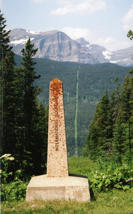
The U.S. and Canadian customs offices are set back from the actual border. We noticed a gap in the trees that made a line as the land sloped up to the east, and a line in the trees as the land sloped down then up to the west. A quite noticeable gap and line. Occasionally there was a stone obelisk in the middle of the gap. Later we learned some of these obelisks were from the original 1846-1874 survey to mark the border at the 49th parallel.
Apparently the entire border with Canada from coast to coast has a 'line' 20 feet across. These photos show the trees that have been cleared. On the prairie the grass is supposedly mowed.
The commission in charge of maintaining the U.S./Canadian border has a web site with info about the border.

After Brian took the photos the same idea came to the two bicycle tourists, a man and women in their 30s, in line behind Brian's car. They asked if we would take their photo with the gap/line in the background. I did. I asked where they were riding from and going to. They started their ride at the Two Medicine area of Glacier Park several days ago. They were going to Waterton for a hot shower. They had planned on only traveling to the Belly River campground but these were primitive campgrounds with no showers. They were willing to ride extra miles for a hot shower.
The Canadian customs got a few more officials out to work the line of vehicles. A young 20-something woman came to our car. First she asked me if I was taking photos of the border crossing, its buildings, and the officials. "No. Just the line in the trees indicating the border." It was a dull ordinary building not worth a photo.
A short number of standard questions (alcohol, cigarettes, firearms, more than 10,000 in currency, the nature of out visit) and we were allowed through. Now the speed limit signs were in kilometers. Good thing all cars today are in miles and kilometers as the road's speed limit went up and down even though it was mainly forest or farmlands on each side.
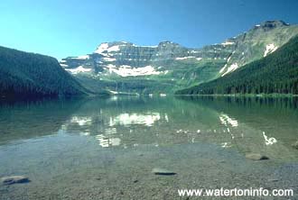
We had less than 40 minutes to drive to the Waterton townsite to catch the 1 pm boat tour. I had researched Waterton Park and the boat times on the internet. We arrived with 20 minutes to spare. The fee to enter the Waterton Park was $7 each Canadian or $6.20 U.S. The boat tour tickets cost 28 Canadian or $26.67 U.S. I got .35 cents in Canadian change.
We grabbed a few bites to eat for lunch before the boat started to load people. We were at the end of the line and did not get choice seats. The boat wasn't even half full so the seats we got weren't half bad. We were able to sit on chairs outside on the upper deck. This was good and bad. Good in that we had good viewing. Bad in that we got a little sunburned and very wind blown. My upper legs got sunburned. I didn't wear my hat as it was very windy. The tour guide said this lake is one of the windiest areas on the continent.
 The boat was built here in the 1920s especially for the Waterton Lake. The boat was designed so it would cut through the waves and not get tossed by them. The ride was very smooth even through the lake was choppy due to the wind.
Originally the Great Northern railroad built the boat. A dress code was enforced and the boat rides had a band and held dances inside on the main deck.
While the boat is owned by Canadians, it is registered in the U.S., inspected by the Coast Guard, and U.S. law stipulates it be operated by a U.S. pilot. During the winter it is stored in its original building over on the U.S. side of the lake near Goat Haunt, Montana.
By the way, the "haunt" in Goat Haunt is an early 20th century phrase meaning "a place much frequented" and does not have a ghost connotation. A nearby mountain used to have far more goats than the other mountains, therefore the name.
 The boat ride to Goat Haunt, Montana as the south end of the lake took almost an hour.
The boat slowed at the border so we could see the cut in the trees on each side of the lake. This line apparently runs the entire length of the U.S. Canadian border. The tour guide said she seen in the prairie fields where the border line was mowed in the grass. Even out here we could see some of the obelisks marking the border as it rose up the steep mountain overlooking the lake.
Speaking of our tour guide she looked to be 17 years old and had "supermodel" looks and demeanor. She had an attractive face and was tall and thin with no curves and little bust. Her large designer sunglasses added to the supermodel look. She spoke in a world-weary manner that was way beyond her young age. It was near the start of the tourist season so she shouldn't have been bored yet by repeating the same spiel trip after trip day after day. Brian later said "supermodel" also crossed his mind. In addition to her explaining things the pilot let her operate the boat when docking and undocking the boat.
At Goat Haunt, we had a 20 minute layover. Goat Haunt had a joint Canadian/U.S. building that was little more than restrooms as a planned exhibit wasn't in place yet.
 A short paved path led around the tip of the lake to a large open observation building for a better view. Next to the building was a small U.S. ranger station.
To go further and hike on any paths one had to go through customs. That meant showing two forms of id. Also only U.S. and Canadian citizens could cross the border. Being so remote they had no way to check on other nationalities. They had three rangers/border patrol people for this crossing. Their ranger shack was barely big enough to hold all of them.
One ranger was leading a 1 mile hike. I was interested in going on this hike, or another short hike, as we had traveled so far and it would be a shame to turn back so soon. Brian wasn't up for a hike. He was a little tired from the previous days travel, and also was concerned about returning to Kalispell before it got late and dark. Going on the hike meant waiting for the final boat of the day. We then wouldn't return to Waterton till after 6 pm. The drive was a little over 3 hours long.
We didn't stay. Brian remembered there were several roads to drive in Waterton Park so that would give us something to do before returning home.
During the boat ride back Brian and I sat on the main deck, but at the back of the boat. It was outside but under the upper deck so we had shade and protection from the wind. The tour guide said one of the mountains (whose name I have forgotten) along the lake in Glacier Park has the largest continuous vertical drop in the continental U.S.
Upon returning to the Waterton townsite we walked around the town. At an art gallery I discussed the Canadian school system with the woman running the store. The Canadian schools were not done until the end of the week. We discussed the schools' system of final tests for most grades. For the people who complain about the 'No Child Left Behind' system of testing, it is nothing compared to Canada's far more serious systems of tests.
 We then drove over to visit the Prince of Wales hotel overlooking the north end of the land. A very large wooden building originally built by the Great Northern Railway.
The doorman wore a skirt. Or I should say, a Scottish kilt. Interestingly none of the female employees wore skirts; they were all dressed in black slacks. Most employees, including the woman, wore ties with the red design of the kilt.
 The hotel sits on high ground overlooking the lake. In front of the hotel overlooking the lake we stood in the strong breeze, or leaned into it is more like it.
Another couple asked us to take a photo with her camera, and I did so. I hope it comes out as it was difficult to remain still in the wind. I tossed my sunglasses to the ground at my feet in order to take the photo and later found them a yard behind me.
We then drove to Cameron Lake.
 Along the road to the lake is the first oil well drilled in Alberta. It was discovered when the locals noticed that quite a number of bears gathered in this area. They found the bears would roll in the oily waters of a nearby stream apparently in order to keep the bugs at bay. The oil well has gone dry long ago.
Cameron Lake is along lake situated in a cirque. The southern end of the lake is in the U.S.
One could rent a variety of boats, fishing boats, canoes, kayaks, and foot paddle boats. The price to rent a paddle boat or canoe was $25/hr Canadian. We hiked along lake shore until the trail ended 3/4 of the way along the lake.
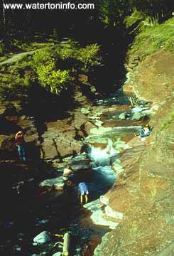 After driving back to the Waterton townsite we took another road to Red Rock Canyon. Should have been called Red Rock Stream. While the stream was down in the ground a little bit, nothing I would call a "canyon".
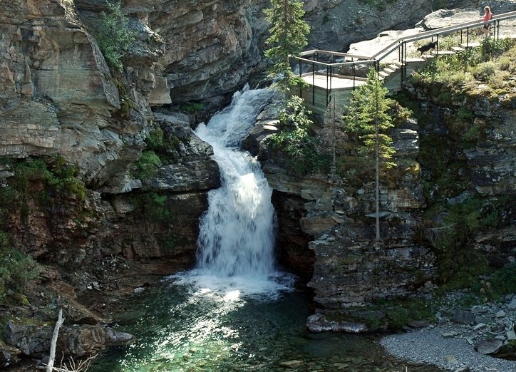 The trail to Blakiston Falls was 1 kilometer so I was able to talk Brian into hiking there. Once we finally reached the falls Brian felt we had walked more than 1 K in distance. The Park had built two wooden observation decks; one at a distance to view the falls, the other next to the falls.
While at the second overlook I met the man from the couple who I took a photo of in front of the Prince of Wales hotel. The guy was a short, round, jovial, very expressive and friendly man in his 50s. He wore a tshirt that said "Mellow Mushrooms" on it. The shirt seemed so appropriate. He reminded me of a cartoon monkey.
His wife joined us from the first overlook. She was taller and thin. She was the camper and preferred tents while he preferred to sleep in the van. He would complement her while downplaying his achievements. I thought she might be his girlfriend, but no, they were married. I forgot to ask for how long. They seemed like newly weds.
He offered to take a photo of Brian and I. I think it is the only photo of the two of us as Brian seemed to take mainly landscape photos and would grumble when people wandered into his photos before he was finished focusing his camera.
We learned the couple is from North Carolina, though they didn't have that southern accent. They own a second place in SW Montana.
While they walked faster than the rate at which Brian and I ambled, we kept up with them on the walk back to the parking lot. The walk went quickly as he would come up with funny non-sequitur stuff and she would bounce right back with a funny quip based on his comments. It was almost like they had a comedy routine.
"Monday, Tuesday, Wednesday, Thursday, Friday. I'm on vacation! Who needs to change their shirt!"They both had nice cameras (according to Brian as I don't pay attention to stuff like that).
"You do!"
"I do?"
"The reviews said 'best camera ever made'. The next year the reviews said 'worst camera ever made'. It took lousy photos so I bought the new camera and gave this one to my wife. Now she takes the best photos using it."Near the parking lot she showed us a patch of "prairie wind" flowers that were still growing and not at the flower stage. The flower was closed but whirling around it were thin reddish tendrils. Quite fascinating. I had never seen such a flower before.
Remember that Brain was concerned that taking a hike and returning on the last boat of the day after 6 pm would mean a late drive back to Kalispell? It was now after 8 pm when we left Red Rock Canyon.
At the U.S. border we were the only car. One customs official came out to take our drivers licenses and enter the info into their computer. Another official checked the car's trunk. We got the standard questions about alcohol, cigarettes, firearms, and why and how long we were in Canada. There must not be any warrants out for our arrest as he returned our driver's licenses and we were allowed back into the U.S.
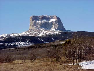
Chief Mountain stood tall and alone as we drove. The Belly River parking lot next to the customs building had a number of cars. There must be a number of backpackers on Glacier's Belly River system of trails. When did I backpack some of those trails? 1991? My, time flies.
Shortly after entering Glacier Park at the St. Mary entrance we saw two herds of antelopes. Brian stopped at a St. Mary Lake overlook to see if it was worth taking a photo of an island in the setting sun's light. A man came walking and carrying a large professional looking camera and tripod. I asked him about photo taking and he grumbled about the light and said that he was going to try another spot as the thin clouds may move and the right light return. Off he went.
Before this stop we had passed a woman jogging along the road. As we approached she jumped in the shallow ditch to continue her running. Leaving this overlook we again passed this woman and she did the same thing. We both wondered why she didn't run in the other lane against the traffic so she didn't have to jump into the ditch each time a car approached.
As we neared Logan Pass we saw parts of the tops of mountain lit by the last of the setting sun. The sun also painted the high thin clouds with the pastel colors of pinks and blues.
It was after 11 pm when we finally got home. Poor Brian, past his usual bedtime.
Since beginning the ranching life I rarely wear my sandals. After two days wearing and hiking in sandals my feet were sore. Tomorrow, shoes!
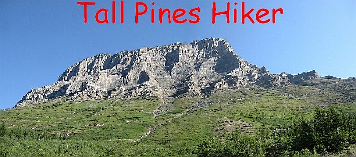
Btw - none of the photos in this post were taken by Brian. I found them on the web to illustrate the area.
Saturday, July 1, 2006
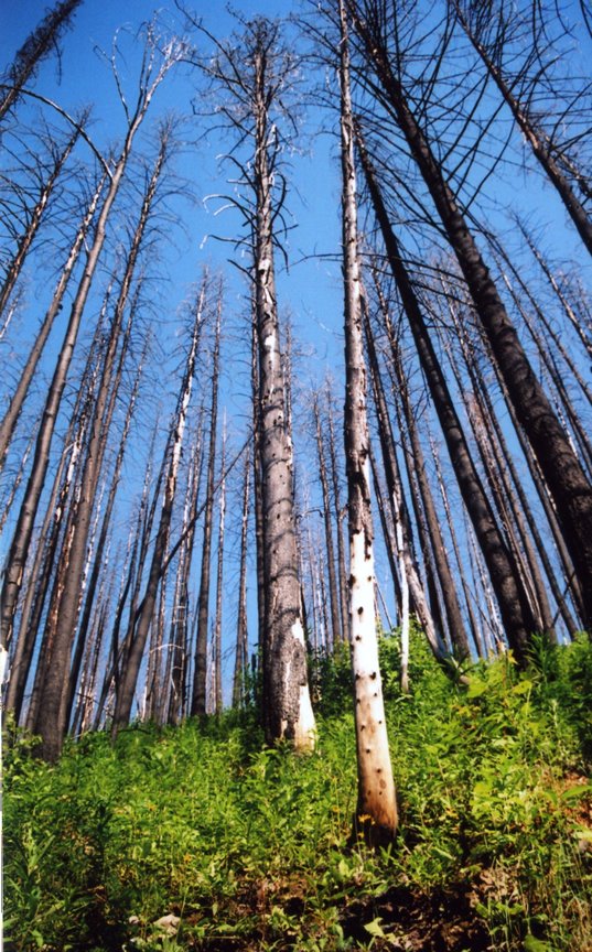
Burnt trees at The Loop
Here is a photo of burned trees at the Loop in Glacier Park. These trees were burnt in 2003 from the Robert fire. Each year since, when friends come visit me, I have taken a photo near this area and placed links to them on my blog's sidebar. This photo was taken during Brian's visit. I used his camera to take the photo.

Here is the 2005 photo:

The 2004 photo (taken by Tina):

The following photo was taken by Brian this year:


Here is the 2005 photo:
The 2004 photo (taken by Tina):

The following photo was taken by Brian this year:
Subscribe to:
Posts (Atom)
