The metal and wooden signs indicating the trail seem redundant, but as the metal sign seems to often be mistaken for a deer, the small wooden signs may be necessary.
Friday, September 9, Patti, Joyce, Glenda and I hiked to the Geiger Lakes and Lost Buck Pass in the Cabinet Mountains south of Libby, Montana. Glenda is Joyce's friend. This is the first time I hiked with Glenda. While everyone else wore shorts as the temperature was predicted to reach 90 degrees, Glenda wore long pants - blue jeans. Even so, she did well.
We got a late start as I had to pick up my neighbor from the train station and the train was about one hour and forty-five minutes late. Then it was a long drive to the trail head and we were slowed by traffic. These two older men on motorcycles were going around 10 mph under the speed limit. They were going so slow that a pickup pulling an RV travel trailer passed them and sped off before I took this photo.
We didn't get going on the trail until 11:40 am. This was late start for a hot day and a trail that gained about 2334 feet in the four miles to Lost Buck Pass. Maybe it is due to all the recent hikes with a decent elevation gain, but this hike did not seem steep. It was a steady climb though.
Start: Trail head Trail End: Lost Buck Pass, junction with Cabinet Divide Trail 360
Elevation: 3,666 feet Elevation: 6,000 feet
Length: 4 miles
Directions: From Libby, 24 to 26 miles south on US 2. Turn right onto West Fisher Road 231 and continue for 6 miles. Turn left on the Lake Creek road, and after 1/2 mile., turn left again on the Geiger Lakes road. Continue 2 miles to the parking area. The trail leaves the road about 100 feet before the parking area. Once you leave Hwy 2 the roads are gravel. While the last 2 miles is on a rougher and narrow road, all roads are usable by any type of vehicle.
 Description:
This trail (# 656) takes you past Lower and Upper Geiger Lakes.
Lower Geiger Lake is reached at about 2 miles.
The trail continues about another mile to near Upper Geiger Lake.
Trail 656 climbs and continues about another mile to Lost Buck Pass and Trail 360, offering scenic views including an overlook to the west into Wanless Lake.
A number of social use trails lead from trail 656 to Lower Geiger Lake. A few trails lead from trail 656 to Upper Gieger Lakes. The junction with trail 115 that goes along the 4th of July Creek is not marked but is easily seen.
Trail 656 is not brushy and appears to get plenty of use. Most of the trail is in the trees and on a hot day provided relief from the sun. About the last half mile is out in the open as it makes it final push to Lost Buck Pass. Some - not many - trees are around the pass.
Near the start of the trail, where it crossed Lake Creek, is this excellent bridge. It is larger and more sturdy than any other bridge I've hiked across in NW Montana. Even the bridges in Glacier Park pale in comparison.
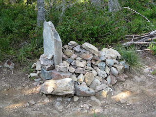
This was located on a switchback between Lower and Upper Geiger Lakes. The large flat rock must have inspired someone to pile the rocks like a grave.
We did not stop at the two lakes on the way to the Pass due to our late start, but did find that we had time to visit them on the way back to the trail head. There were lots of mosquitoes at the Upper Geiger Lake so we did not stay there but for a few minutes. No mosquitoes were at the Lower Geiger Lake.
We met three young men setting up camp on a higher knoll at the foot of Lower Geiger Lake. Their plan was to fish the lakes with the goal of reaching Wanless Lake. Two of the men had been to Wanless Lake last year. Apparently there is no real trail to the lake but their route was to take a game trail from the side of Carney Peak at Lost Buck Pass until the trail petered out and they had to bushwhack the rest of the way down to the lake.
Wanless Lake as seen from the overlook near Lost Buck Pass. Beyond the lake is Engle Peak. The mountain on the left side is Goat Peak.
Carney Peak is to the north (right) of the Pass and people do hike to the top of it. It seems doable but I did not see an obvious way to the top when I looked it over. The two young men said they just scrambled straight up the scree when they climbed it last year.
Even though we stopped and picked some huckleberries on the way back to the car, we made good time and reached the car sometimes after 7 pm. A few times we browsed on some huckleberries on the hike to the Pass. It appears that many of the huckleberries had already been picked this year but we found some on the down-slope side of the trail where it was harder to get to. With Patti and Joyce's help I picked a plastic sandwich bag full of huckleberries to take to my Uncle Curt and Aunt Cathy as thanks for letting me stay at their house before my Alaskan cruise. Wouldn't you know it? I forgot the huckleberries in my refrigerator when I packed.

More photos:
 |
| Below the foot of Lower Geiger Lake |
Trees in Lower Geiger Lake.
 |
| The foot of Lower Geiger Lake |
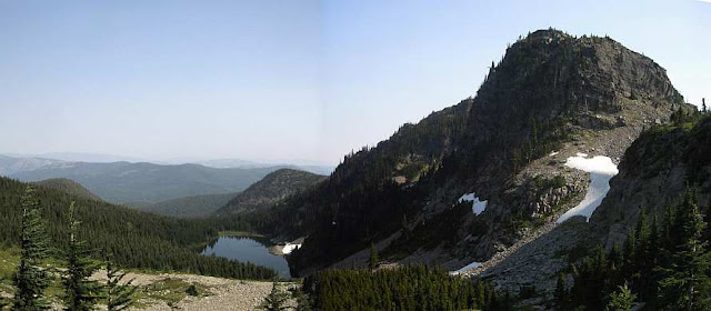
Upper Geiger Lake. The mountain on the right is Carney Peak. Lost Buck Pass is the saddle to the right of center.
 |
| Upper Geiger Lake |
Upper Geiger Lake as seen from near Lost Buck Pass.
September and there is still snow near the pass.
A few interesting dead trees from near the overlook near Lost Buck Pass. The mountain on the right is the 'backside' of the mountain in the photos of Upper Geiger Lake.
Here is an excellent video of the trail lakes and mountain from another person: http://www.youtube.com/watch?v=BcVV0M2MQbs The video length is 8:50.


No comments:
Post a Comment