Showing posts with label Kootenai National Forest. Show all posts

Tuesday, July 19, 2016

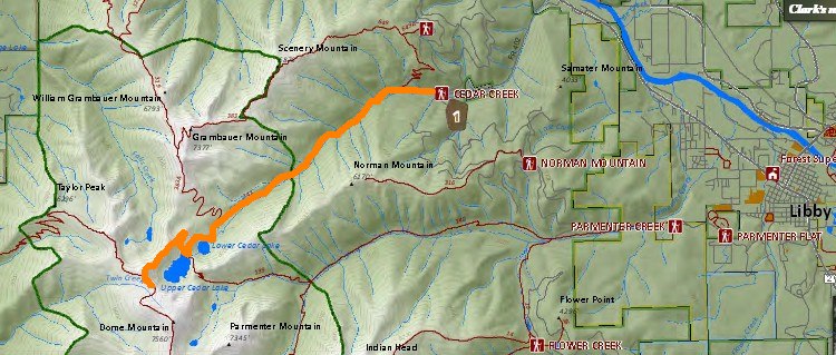
Lower and Upper Cedar Lakes

On Tuesday July 19 Patti and I hiked to Lower and Upper Cedar Lakes and most way up Dome Mountain.  Even though Patti, Lynda and I had hiked the Upper Holland / Sapphire Lakes loop two days earlier on Sunday (and Patti and I were still recovering), Patti had a free day waiting for the movers to come pack up her stuff for her move to Wisconsin and she wanted to go on a hike.  So did I.  I reminded Patti of her interest in going on the Cedar Lakes hike with me as she was very impressed with the lakes when she did the hike a few years earlier with Mary.

So at 7 pm on Monday we decided to hike to Cedar Lakes.  A last minute thing and too late to get more people to join us, especially on a weekday.

Cedars Lakes is in the Kootenai National Forest in the Cabinet Mountains west of Libby, Montana.


The distance we hiked was 15 miles.

We started at an elevation of 2997 ft and the highest elevation we hiked was 6941 ft.  The elevation gain/loss overall on the hike was 4157 ft. 


We hiked for 7 hours and 4 minutes and stopped and enjoyed the scenery for 2 hours and 15 minutes.  Our total time from start to finish was 9 hours and 19 minutes.  A good day of hiking.

Overall the weather was good.  We were happy to have the shade of the trees on the climb up to protect us from the hot sun.  Clouds came as we hiked back to Patti's car and a brief rain shower with large raindrops got us wet.  The thick tree canopy didn't keep us dry.

Between the distance and  the elevation we both were tired at the end of the hike and happy to be back to the car. 


The Forest Service Road to the trailhead is in excellent condition. There was ample parking at the trailhead.

The trail mostly follows along Cedar Creek.   The thick cedars and water reminded me of western Washington.


The hike was a steady climb to both Lower and Upper Cedar Lakes.  The trail was very clean all the way up and at no point did we lose the trail (though the junction with Upper Cedar Lake isn't marked, its fairly obvious).  

There were a good number of groups of downfallen trees.  Most all were cut allowing for easy passage.  The exception was the spur trail to Lower Cedar Lake.  None of the downfall was cleared and we had to search to  find a way around the trees to reach the lake.

Huckleberries were all along the trail, with the majority being after you pass the Wilderness boundary. 

The trail to the lower lake was mostly in the trees with good shade.  To the right of the trail is the young regrowth after a previous forest fire which allows for some open views of Scenery Mountain and later Grambauer Mountain that rises up from the trail.


When hiking between Lower and Upper Cedar Lakes we met a father, son and their dog who had been staying at Upper Cedar Lakes.  The dog growled at us when they approached us but the dog didn't do anything.


The dog had his own pack.


At the Upper Cedar Lake we talked a while with a grandfather hiking with his grand-kids. He grew up around Libby but now lives in eastern Washington.  He seemed to be enjoying the hike more than the grand-kids.

Granddad, grand kids, and Giant Patti.


Above Upper Cedar Lake we hiked up and around the backside of the shoulder of Dome Mountain.  On the backside was a short bridge over a steep deep drop.


The view from near the bridge of an unnamed lake in another valley.


For 24 more photos from our hike: https://goo.gl/photos/akPcdyfrvc2RFSdj9


Video of Cedar Creek  (1:35 long): https://youtu.be/9wWZWTRaYNI

Video of Lower Cedar Lake (22 seconds): https://youtu.be/cM9TcLXyrNQ

Video of Upper Cedar Lake (30 seconds): https://youtu.be/tvTZWQV24f8

Video on Dome Mountain of both lakes (36 seconds):  https://youtu.be/MklwwS8N_CU

Saturday, May 9, 2015

Bear Lakes

On Saturday May 9 Patti and I hiked to the Bear Lakes in the Kootenai National Forest south of Libby, Montana.  There are three lakes.


Three Bear Lakes (upper left corner) and the Silver Butte Road (the lower right corner).

Three Bear Lakes

Middle Bear Lake.  The rock at the bottom of the lake will be seen in my photos later.


Location: 28 miles south of Libby on US 2. Turn right onto Silver Butte Road 148 and travel a little over 9 miles to the trail sign. Turn right and continue .1  mile under the power line. Ample parking is available at the trailhead due to the cleared area under the power line. 


Trail number: 531   (On the Cabinet Mountains Wilderness Map this trail is designated as Trail 178.)

Length: 3.0 miles 

Trailhead Elevation: 3,700 feet
Trail End: Junction with Trail 63.   Elevation: 5,900 feet
Elevation gain: 2200 ft.


The Silver Butte Road is little more than a one lane gravel road. 


At quite a few places along the road were areas being logged or had been logged.  Due to the Spring thaw it appears logging operations were suspended.  A half dozen or more places had logs stacked with signs declaring that firewood gathering was prohibited.  The road was rutted from the earlier logging activity and Patti had to drive slow and carefully.

Patti and I thought the trail to the lakes would be gradual and perhaps would follow a creek.  Wrong on both parts.  The trail climbed steadily up the mountain side.  We had little downfall across the trail.

Because we had little snow during our hike to Snyder Lake last week at an elevation a little over 5000 ft, and because the Cabinet Mountains had less snow this Winter, we figured that what snow we would encounter would be small, scattered and manageable.  Well... up to about 5500 ft we had little snow.  For the next few hundred feet of elevation gain the snow was isolated and we could either walk around it or easily across it in a few steps.  Then as the elevation rose the snow became more continuous with scattered ground.

While the snow was soft enough for firm footing, the snow was hard and solid and I didn't post hole.  Patti had more post hole problems, even when stepping in my footsteps.  The snow and elevation gain was wearing Patti out. While I was certain we were still on (above) the trail, Patti at times had doubts I was keeping us on the trail.  A short time after we hopped on rocks and crossed Iron Meadows Creek she waited in a snow free area and ate some food while I continued on.  I was certain we were close to the lakes.

After a half mile I reached the junction with the trail to the Iron Meadows.  This was close to the middle Bear Lake.  I had missed the spur trail to the first Bear Lake.  This spur trail may have been the one time I was initially unsure which way the trail went through the trees.  Shortly before I reached the trail junction to the Iron Meadows some trees had orange ribbons tied around them to indicate the trail.

Apparently the middle Bear Lake has a spur trail to it but it was impossible to find under the snow.  I could not see the lake from the trail junction, but due to the mountain I could see through the trees I felt the lake lay below in the bowl below the mountain.

I bushwhacked through the trees.  After a short distance I could see the lake below.  It was quite a drop to the lake.

A little steep.  Don't slip!

I discovered I should avoid large shaded areas as the snow was too hard to dig my shoes into.  The snow in the sun was soft and I could set my footsteps.  I went about halfway down to get a photo of the lake un-obscured by the trees before climbing back up the steep mountainside and then returning to Patti.


I generally could follow my footsteps back the way I came.  In a few large shadowy areas my footsteps were faint to non-existent and I had to take care to follow what I felt was the trail path through the trees. A few times I called out for Patti but she never heard me.  I found my way back to Patti. 

Even though she was rested she decided not to go up to the lake and will return after the snow has melted.  At that time we can complete out intended itinerary of visiting Bear Lake then continuing on a divide trail over to Baree Lake before looping back to the car.

On the way back to Kalispell we stopped at Middle Thompson Lake and in the sun and warmth we studied Patti's map for other trails in the Cabinet Mountains.  I found a couple interesting hikes with top elevations of only around 5000 ft and with low potential snow levels.

Middle Thompson Lake

For 21 photos from our hike:  https://plus.google.com/photos/109566462412251958234/albums/6147514310857442561?authkey=CM6Z7ZGFhcfxngE

Monday, September 29, 2014

Davis Lookout

On a cloudy Monday September 29, Joyce, Kendra and I hiked to the Davis Lookout in the Salish Mountains in the Kootenai National Forest.  This lookout was in the same general area as the last lookout we hiked to: McGuire Lookout.

Distance roundtrip: I estimate 4 to 4.5 miles
Elevation gain:  from the topo map I estimate 800 or a bit more feet.
Lookout elevation: 6051 ft


We again followed the directions in Kendra's copy of the Fire Lookouts in NW Montana book.   The route description and some photos are the same as I found later on the following summitpost web page:
http://www.summitpost.org/davis-mountain/727113

But... when we reached Forest Service 3532 it was gated shut.  What?!    (This route is marked in purple in the map below.)


Not only one lock fastened the gate, but two locks.  We were locked out.

We didn't have a map so we couldn't look if an alternate route existed.  Time for plan B.   As we drove to the plan B lookout we passed the Murphy Lake Ranger Station.  We stopped in.

We learned FS road 3532 (like the other roads marked in yellow) was closed each year from July 1 to  December 1.  When did the book and summitpost author(s) hike to the lookout? June 29.  No mention that the road could be closed.

Alternatives?
  1. Trail #212. This trail originates at the end of FS Road #7156 just south of Swamp Mountain. It would be very possible to combine Davis Mountain with Swamp Mountain.  The trail is 6.5 miles to Davis Mountain.  13 miles RT - too far for Kendra to hike while she is undergoing radiation treatment.

  2. Trail #279 (Warland Ridge trail) which approaches from the southwest. Approximately 2 miles long (one-way). To get to this TH, drive 17.2 miles on #36, then turn right on FS Road #835. Drive 3.56 miles on #835 to #4424. Turn right on #4424 and drive 3 miles to the TH on the right side of the road. You can also access Warland Peak to the west via this trail...on the left side of the road.
The woman at the ranger station said trail 279 had not been maintained and she didn't know the trail condition.  There could be a lot of blow down. If the trail was similar to the McGuire Lookout trail, the trees wouldn't be thick. We should be able to get around dead-fall for two miles.

Again the gravel forest service roads were in very good condition.  On the map above our driving route is in red.  Trail 279 is marked in blue.

Aerial view


At mile 3 on FS 4424...


is the start of the trail.

Don't worry.  There is an easy place to park your vehicle off road near the trail.


At times the trail could be easily seen as a path through the grass.  Other times the trail was marked by lots of rock cairns.  The trail was easy to follow with little second guessing as to where the trail was located.  We only encountered three or four trees down across the trail.  It was easy to walk around them.


After the first little climb I looked to the NW and think I saw the McGuire, Little Sutton and Sutton peaks where we had hiked last week.


A short distance later we could see the fire tower barely above/among the trees.  What we didn't know is that the trail did not take the shortest distance from point A to B, even though it looked that way on the map (I added the little 'hook' on the end when I marked the trail in blue on the earlier map).

From the lower red X we hiked down a hundred to two hundred feet, then hiked up along the side of Davis Mountain to about the red X on the right.  Then we hiked the fat spine of Davis Mountain to the lookout.  This is why I think the trail is a little over 2 miles long, though on the map the trail goes fairly straight and appears to be no more than 2 miles.

The topography is not that steep so I don't know why a trail wasn't created in the shortest distance possible, unless they wanted the longest shallowest switchback on record. It is a good thing we saw the lookout at this point, else when we walked among the tall trees along the spine we would have questioned if we were on the right trail.  As it was, the walk along the spine was long enough we wondered if we would ever get to the lookout.  And once we were on the spine we lost the views of the valleys until just before reaching the tower.


The present 60' steel tower with 7x7' cab and ladder, along with the accompanying log cabin, were built about 1931, and have been abandoned for several years.
The cabin was pretty cool. Kendra would like to live here. The log walls were in good shape even if the rest of the cabin was not. The three trees next to the front porch must have been 'planted' by birds.  More photos of the cabin, and the outhouse with no view,  are at the link at the end.


The tower's ladder was removed from the bottom two sections of the tower (about 12 ft).

I rattled the tower's "x" on one side and the metal wobbled more than I expected.  Another reason not to try to shimmy up the tower to the ladder.

This tower reminds me of my friend Jeff.  He bought an old fire tower in northern MN and then erected it on his property.  His tower is similar, and may be almost as tall, though his cab on top may be smaller.

For more photos, follow this link:

https://plus.google.com/photos/109566462412251958234/albums/6065132053819826705?authkey=COuzqMXa1sWucg
-

Wednesday, September 24, 2014

McGuire Lookout

On a nice warm and sunny Wednesday September 24 I hiked to the McGuire Lookout with Joyce, Kendra, and Glenda.  Kendra has a book about selected fire lookouts in NW Montana and has a goal to hike to most of them.  She and Joyce had visited about a half dozen lookouts before inviting me to join them to see McGuire Lookout.

Distance round trip to the lookout: 5.3 miles.   Our meanderings on the trail to the NW of the lookout made the trail 6 miles round trip.
Elevation gain to and from the lookout: 808 ft

Background from the Kootenai National Forest brochure and elsewhere: 
On a summit in northwestern Montana, about 19 miles southwest of Eureka at an elevation of 6991 feet, perches McGuire Mountain Lookout.
The lookout was built in 1923. It has a view of Lake Koocanusa five air miles to the west and the surrounding mountains and ridges.
Other historic remains include a root cellar, two outhouse holes, a Forest Service trail accessing the site, an early 1920’s campsite, and painted rock alignment spelling out “MCGUIRE”. The rock alignment is considered historical because the Forest Service began marking its location points this way in 1929 to aid aerial fire patrols.

In 1923, at the cost of $805.87, the Forest Service built the current McGuire Mountain Lookout. Lightning protection was added in 1931. The building was estimated to have a 20-year life. It is an excellent example of the first standardized Forest Service design, the D-6. The D-6 design is a square, wood frame building designed to rest on the ground with pyramidal cupola with windows all around which serve as an observation tower.
The lookout is a square 12' x12' wood frame building, designed to rest on the ground with pyramidal roofs and on top a pyramidal-shaped cupola, with windows all around, which serves an an observation tower. The main floor served as a living quarters for the fire guard. The cabin is equipped with a modern wood stove, 2 twin size bed boards (no mattresses), table, bench, shovel, bucket and cleaning gear. This cabin is very rustic. The building is not wired for electricity and has an outdoor toilet. Water sources are limited in the area and there is no water at the lookout.
The main floor served as living quarters for the fireguard. The fireguard also needed to patrol around the breaks of the mountain to view the Flat Creek watershed to the north. The patrol, including viewing times at three points took fifty-five minutes round-trip.

The end of the era of intensive fire lookouts use came in the 1940’s. As a result, the McGuire Mountain Lookout was abandoned in 1944. It stood vacant until 1983 when the Forest Service began restoring the building. Renovations were completed in 1998 under a PIT Project, making it eligible for the National Register of Historic Places. In 1996, windows replaced the boards in the cupola and the lookout was painted its original green with white trim. Today it is part of the Forest Service cabin rental program.
The lookout is open from June 1 to September 30 (weather permitting).
The cabin rents for $25.00 a night with a 14 day stay limit.

There are a number of ways to drive to the trail head.  Coming from Kalispell we drove through 'downtown' Trego, Montana and continued south on Fortine Creek Rd until we came to Edna Creek Rd (or FS 433) and then turned right onto that road.  Fortine Creek Road is paved and about 5 miles of the Edna Creek Rd is paved.  The rest of the roads are gravel but are in excellent condition with no potholes or rocks until the last 1.3 miles where the road got a little rocky.  But it was not bad.  Kendra drove a Prius and with its low ground clearance it had no trouble on the roads.

Google maps has the time from Trego as 1 hr 15 minutes. While we didn't time the drive it didn't seem like it took us even an hour to drive the route due to the good condition of the roads.  The only thing to watch out for is that there a number of roads in the area and we encountered several major intersections so use Google maps to get a list of the steps if you don't have a copy of the book's route description available.


An example of the many roads.  The short section from the intersection down by "Google" is the one that is a little rockier to drive.  The trailhead (plus a decent area on which to park off the road) are located on the saddle between McGuire Mountain and Sutton Mountain.


The trail takes the long way to the lookout and curves around from the west.  "McGuire" are rocks near the lookout and not an altered image.


There was no sign at the trailhead. We found a paper and plastic sign torn up into pieces at the base of a post.  The trail is nice and the forest along the trail is is open.

The trail goes up 200 to 300 ft then goes down a few hundred feet before going up again.  So the 808 ft of elevation gain is not straight up to the lookout but is gained going to and back from the lookout. The hike is easy.


The rock pile (there are four of them at each corner of the lookout) had cables between them and the lookout.

Near the trees in front of the lookout are some benches to sit on around a fire ring.  The outhouse is a short way down the hill and we also found the remains of the old root cellar.   As you can see, since the lookout was abandoned for fire detection use, trees have started to grow up around the lookout.

While the views are not spectacular as with other lookouts I have been to, nonetheless they are nice of the Salish Mountains.  The lack of large elevation change in the views hide the fact that the lookout is at an elevation of 6991 ft.

There is a trail that goes NW.  We followed it for a while in hopes of seeing more views to the NW and of Lake Koocanusa.  None where to be had.  The walk was nice and for some reason a number of large piles of rocks were placed at various points along the trail.  We came to an area off the trail where a very large section of the ground and rocks were disturbed.  Our guess it was due to a bear searching for grubs.

Someone placed a geocache at the lookout site. I didn't know about it until later when looking up info about the lookout.

http://www.geocaching.com/geocache/GC581QE_mcguire-mtn-fire-lookout 


The forest service had conducted controlled burns earlier and on our drive out we could see and smell smoke from where the afternoon breeze had encouraged smoldering.  There was a large canvas(?) container along the road filled with water ready to pump from if needed.

More photos are at this link:

https://plus.google.com/photos/109566462412251958234/albums/6064383768758275585?authkey=CMDSxOPL86TuWA

A short video from the summit is at this link:

https://www.youtube.com/watch?v=CUr_pElZ2wo&feature=youtu.be
-

Saturday, September 6, 2014

Ross Creek Cedars

On Saturday September 6, on our drive home from our hike to Star Peak, Patti and I drove on MT Hwy 56 past the Ross Creek Cedars scenic area.   Patti had visited the area before but I hadn't.  We went in and walked around for a half mile or so on their scenic loop.  We were a bit tired from the Star Peak hike and still had a distance to drive back to Kalispell.  We wanted to get back to Kalispell before dark.  The deer at night are bad on this stretch of Hwy 2.  Tammy and I hit a deer last year when we drove this road.

When we had returned from Star Peak lookout the temperature was 81 F.  In the Cedars the temperature was in the mid 60s.  Cool and damp.  Good for growing big trees.  Once we left the Cedars area the temperature warmed up.

http://www.libbymt.com/areaattractions/rosscreekcedars.htm


View of the Cabinet Mountains on our drive out of the Cedars area.

Friday, October 4, 2013

Hoskins Lake

While Tammy was holding a Tastefully Simple party in the Yaak area, I went on a short easy pleasant 2 mile hike for a few hours.  Nearby was Hoskins Lake.


Apparently there a number of bears in the area.  I didn't see any.


There is a study being done on bears.  The researchers are trying to gather bear fur on wires to do DNA testing.  From this they can determine the number of unique bears in the area.  A similar study recently was completed in the Rocky Mountains near and around Glacier Park.


Hoskins Lake at the south end looking north.


I walked all around the large lake.   Below is the view of Hoskins Lake looking south.


Until I looked on Google Earth I didn't realize a smaller lake lay to the north of Hoskins Lake. Here is the view looking north of Hoskins Lake.  Here you can see why I never realized there is a lake on the other side of this meadow.


This area might be good moose habitat.  But I didn't see any moose.   I could see - and hear! - three squirrels who were not happy I was in their area.


As I mentioned I walked all around the lake.  The best part of the trail is on the east side (right side) of the lake.  The trail is pretty established on the east side.  Part way up and along the lake is a campsite area for one and a fire ring.

On the west side of the lake the trail is easy to follow for about halfway up the lake.  The upper half is doable but you'll have to pick your way along in some parts over fallen trees. It is not hard as there is little undergrowth.

Not the trail, but a representative view of the area where the trail comes and goes.

There are a few large rocks near shore on the west side and more places to access the lake on the west side than the east side.


Follow this link to see more photos of the lake.

https://plus.google.com/photos/109566462412251958234/albums/5934083515831401729?authkey=CIvakNXEtIKSHw