
So at 7 pm on Monday we decided to hike to Cedar Lakes. A last minute thing and too late to get more people to join us, especially on a weekday.
Cedars Lakes is in the Kootenai National Forest in the Cabinet Mountains west of Libby, Montana.

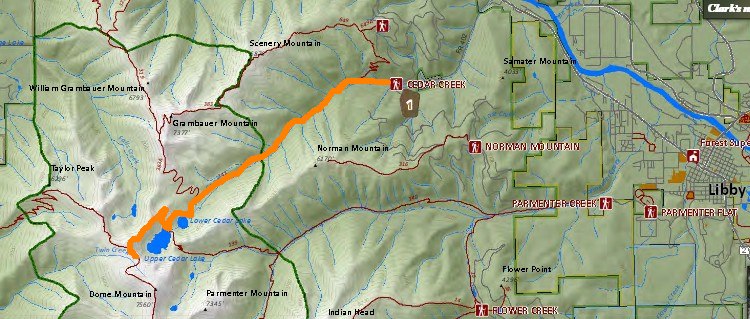
The distance we hiked was 15 miles.
We started at an elevation of 2997 ft and the highest elevation we hiked was 6941 ft. The elevation gain/loss overall on the hike was 4157 ft.

We hiked for 7 hours and 4 minutes and stopped and enjoyed the scenery for 2 hours and 15 minutes. Our total time from start to finish was 9 hours and 19 minutes. A good day of hiking.
Overall the weather was good. We were happy to have the shade of the trees on the climb up to protect us from the hot sun. Clouds came as we hiked back to Patti's car and a brief rain shower with large raindrops got us wet. The thick tree canopy didn't keep us dry.
Between the distance and the elevation we both were tired at the end of the hike and happy to be back to the car.
The Forest Service Road to the trailhead is in excellent condition. There was ample parking at the trailhead.
The trail mostly follows along Cedar Creek. The thick cedars and water reminded me of western Washington.

The hike was a steady climb to both Lower and Upper Cedar Lakes. The trail was very clean all the way up and at no point did we lose the trail (though the junction with Upper Cedar Lake isn't marked, its fairly obvious).
There were a good number of groups of downfallen trees. Most all were cut allowing for easy passage. The exception was the spur trail to Lower Cedar Lake. None of the downfall was cleared and we had to search to find a way around the trees to reach the lake.
Huckleberries were all along the trail, with the majority being after you pass the Wilderness boundary.
The trail to the lower lake was mostly in the trees with good shade. To the right of the trail is the young regrowth after a previous forest fire which allows for some open views of Scenery Mountain and later Grambauer Mountain that rises up from the trail.

When hiking between Lower and Upper Cedar Lakes we met a father, son and their dog who had been staying at Upper Cedar Lakes. The dog growled at us when they approached us but the dog didn't do anything.

 |
| The dog had his own pack. |
At the Upper Cedar Lake we talked a while with a grandfather hiking with his grand-kids. He grew up around Libby but now lives in eastern Washington. He seemed to be enjoying the hike more than the grand-kids.
 |
| Granddad, grand kids, and Giant Patti. |
Above Upper Cedar Lake we hiked up and around the backside of the shoulder of Dome Mountain. On the backside was a short bridge over a steep deep drop.

The view from near the bridge of an unnamed lake in another valley.

For 24 more photos from our hike: https://goo.gl/photos/akPcdyfrvc2RFSdj9
Video of Cedar Creek (1:35 long): https://youtu.be/9wWZWTRaYNI
Video of Lower Cedar Lake (22 seconds): https://youtu.be/cM9TcLXyrNQ
Video of Upper Cedar Lake (30 seconds): https://youtu.be/tvTZWQV24f8
Video on Dome Mountain of both lakes (36 seconds): https://youtu.be/MklwwS8N_CU

No comments:
Post a Comment