Last November Patti and I hiked up to the Numa Ridge Lookout (story and photos - click here). This Saturday we decided to hike to the lookout again, this time when it wasn't so cold. In fact, with the forecast to have the high temperature in Kalispell at 90 F degrees, hiking up north and up a mountain would be cooler. And it was, as the temperature up at the lookout was pleasant.
The hike was 11.2 miles round trip with an elevation gain of 2930 ft up to an elevation of 6960 ft at the lookout.
Because it was going to be a hot day, Patti, Mary and I got an early start. They were at my place after 7 am and we were on the trail after 9 am. The others in our hiking group had other plans.
While a good number of people were at Bowman Lake, we only saw six people on the trail to the lookout.
We did see horse poop, bear scat, and wolf scat. Here is the wolf scat.
The lookout is staffed, and a young college student was there this summer. She was friendly and helpful in naming the peaks as Patti forgot her map. She also explained the trail heading north to the false summit did not go down to Akokala Lake. Instead it was the old trail up to the lookout. Because the trail was in the bowl to the north of the lookout, the trail melted out late and had other issues. So years ago the Park created the switchback trail to the south of the lookout. The old trail starts at the first switchback and is in pretty good shape for being abandoned. There were only a half dozen trees growing on the trail and about the same number of downfall over the trail. I would recommend going down the old trail instead of up. Use the switchback trail to go up.
At the lookout was another couple who were from Great Falls, MT. Their son was climbing Rainbow Peak with a friend this day. To do that, they had to kayak quite a few miles on Bowman Lake to where they would start their climb. There is no trail so they bushwhack up to above the tree line then climb the rest of the way. They planned on it only taking 12 hours. Oh! To be 24 years old again!
In the photo, Rainbow Peak (9,891 ft) is the large mountain in the center and to the left. Mt Carter (9,843 ft) is in the far background and Square Peak (8,777 ft) is the smaller pointy peak to the right of center. The climber's route was up the area between Rainbow Peak and Square Peak. At the saddle between the peaks they would climb Rainbow just on the other side of the ridge line to the top.
Mary has not hiked much this year as her knee and hip has been bothering her. She did fine hiking up, but the last few miles hiking down were hard on her. She had to stop and take a pain pill.
Back at the foot of the lake we rested. Mary read, Patti swam, and I got to use Patti's kayak. That is the first time I have been in a kayak.
Afterwards we stopped at the Northern Lights Saloon in Polebridge for supper. It was busy but not crowded. It was steak night and Patti and I had steaks. Mary, leaning towards being a vegetarian, had some sort of salad. The food was very good.
Bowman Lake as seen from the trail and later from the lookout.
The trail starts at the far end of the lake. It follows the lake .7 mile then climbs up the ridge that is right of center. The trail passes just right of the small lake.
Akokala Lake, as seen from just north of the lookout.
From the lookout, a view of the false summit of Numa Peak. The true summit is behind this false summit. A climb to the top of this false summit doesn't seem to be too difficult and someday I want to do it.
On the right, the Numa false summit. On the left, Reuter Peak (8,763 ft). In the background... I don't know.
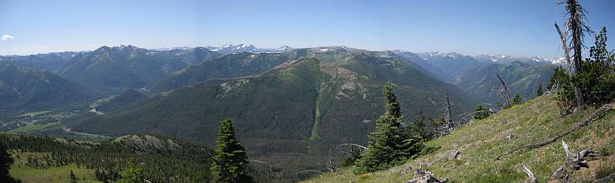
Reuter Peak and the Whitefish Range in the background.
Snow is still near the abandoned old trail north of the lookout.
Views of the lookout from the old trail.
Saturday, August 13, 2011
Numa Ridge Lookout in August
Labels:
Bowman Lake,
Glacier,
Hiking,
Lakes,
Lookouts,
Mary,
North Fork,
Patti,
Polebridge
Saturday, August 6, 2011
Elk Mountain in Glacier Park
Saturday, August 6, Patti and I hiked up to the top of Elk Mountain in Glacier Park. When I say "up" I mean UP! I climbed 3146 ft over 3.7 miles with 99% of the elevation gain in the last 2.5 miles. That's over 1250 ft each mile of the 2.5 miles. Or (if I have my math right) about a 23.6% grade. I think this is the steepest trail in Glacier Park.
In this topo map, we started near the little brown huts along Hwy 2. We hiked 1.2 miles to the top brown hut which is the Fielding Patrol Cabin. From there we turned right and went 2.5 miles up to the top of Elk Mountain.
Because the temperature was forecast to be in the mid-80s under a clear sky, we got an earlier than normal start. That was good as it was a cool morning. When I got out of bed it was foggy from the rain we had the previous evening. The fog quickly burned off.
Our early start was a good idea as when we descended mid afternoon I was warm and sweating - more so than when I climbed up. Keep in mind going down was plenty hard. The trail was so steep that I had to work at slowing down and not losing control. Making that harder was a good part of the trail was loose gravel on hard ground - not an ideal surface for going down a steep trail.
A van with South Dakota license plates was parked near the trail head. We never saw these people so I believe they were backpacking on the Fielding - Coal Creek trail. Near the start of our descent we met three women and and one man hiking up Elk Mountain. They were from Whitefish and we saw their Subaru car when we got back to the trail head. They were the only people we met.
A couple photos showing the trail. It is hard to capture how steep the trail is.
There were still some nice wildflowers growing on the mountain.
Views towards Snowslip and Running Rabbit Mountains in the center of the photo. To the right is Scaplock Mountain. All the mountains I named are in green.
A better view of Scaplock Mountain is on the right. We could see the lookout when using binoculars. The Scaplock lookout is above the white spots on the green mountain, just right of center. I've been up Scaplock Mountain twice: once in the Fall and once on snowshoes February or March 2010. The water at the bottom of the valley is Ole Creek.
This view of Scaplock Mountain shows how steep Elk Mountain is.
Nearing the false summit.
Elk Mountain top as seen from near the false summit.
Climbed some more and still not much closer. Trail is steep. The very strong wind didn't help.
The view at the top.
In case you overlooked it, this is the location of the old lookout. Glacier Park built the lookout in 1930 and destroyed it in 1963. Not much area at the top of Elk Mountain. The lookout took up most of it.
Little Dog Mountain.
Sheep Mountain. Brave Dog Mountain. And more. The trail at the bottom of this valley eventually leads to Ole Lake, then Firebrand Pass to the right of the photo, and Scaplock Mountain to the left of the photo.
You may have noticed it sticking up in the background of several of the earlier photos... Mount St Nicholas.
A number of trains came by when we were on Elk Mountain. The trains were very long and mainly carried shipping containers. Click on the photo to get a larger view to see the train going around the multiple bends. The engineer can't see the end of the train.
It was windy at the top, but not as windy it had been between the false summit and the top.
Another person's description and photos of Elk Mountain: http://www.summitpost.org/elk-mountain/425406
Jake, who I hiked with last month, posted a 3 minute video of his hike up Elk Mountain earlier this year: Jake's video.
In this topo map, we started near the little brown huts along Hwy 2. We hiked 1.2 miles to the top brown hut which is the Fielding Patrol Cabin. From there we turned right and went 2.5 miles up to the top of Elk Mountain.
Because the temperature was forecast to be in the mid-80s under a clear sky, we got an earlier than normal start. That was good as it was a cool morning. When I got out of bed it was foggy from the rain we had the previous evening. The fog quickly burned off.
Our early start was a good idea as when we descended mid afternoon I was warm and sweating - more so than when I climbed up. Keep in mind going down was plenty hard. The trail was so steep that I had to work at slowing down and not losing control. Making that harder was a good part of the trail was loose gravel on hard ground - not an ideal surface for going down a steep trail.
A van with South Dakota license plates was parked near the trail head. We never saw these people so I believe they were backpacking on the Fielding - Coal Creek trail. Near the start of our descent we met three women and and one man hiking up Elk Mountain. They were from Whitefish and we saw their Subaru car when we got back to the trail head. They were the only people we met.
![]() |
Blue Grouse |
A couple photos showing the trail. It is hard to capture how steep the trail is.
There were still some nice wildflowers growing on the mountain.
Views towards Snowslip and Running Rabbit Mountains in the center of the photo. To the right is Scaplock Mountain. All the mountains I named are in green.
A better view of Scaplock Mountain is on the right. We could see the lookout when using binoculars. The Scaplock lookout is above the white spots on the green mountain, just right of center. I've been up Scaplock Mountain twice: once in the Fall and once on snowshoes February or March 2010. The water at the bottom of the valley is Ole Creek.
This view of Scaplock Mountain shows how steep Elk Mountain is.
Nearing the false summit.
Elk Mountain top as seen from near the false summit.
Climbed some more and still not much closer. Trail is steep. The very strong wind didn't help.
The view at the top.
In case you overlooked it, this is the location of the old lookout. Glacier Park built the lookout in 1930 and destroyed it in 1963. Not much area at the top of Elk Mountain. The lookout took up most of it.
Little Dog Mountain.
Sheep Mountain. Brave Dog Mountain. And more. The trail at the bottom of this valley eventually leads to Ole Lake, then Firebrand Pass to the right of the photo, and Scaplock Mountain to the left of the photo.
You may have noticed it sticking up in the background of several of the earlier photos... Mount St Nicholas.
A number of trains came by when we were on Elk Mountain. The trains were very long and mainly carried shipping containers. Click on the photo to get a larger view to see the train going around the multiple bends. The engineer can't see the end of the train.
It was windy at the top, but not as windy it had been between the false summit and the top.
Another person's description and photos of Elk Mountain: http://www.summitpost.org/elk-mountain/425406
Jake, who I hiked with last month, posted a 3 minute video of his hike up Elk Mountain earlier this year: Jake's video.
Subscribe to:
Posts (Atom)