
In this topo map, we started near the little brown huts along Hwy 2. We hiked 1.2 miles to the top brown hut which is the Fielding Patrol Cabin. From there we turned right and went 2.5 miles up to the top of Elk Mountain.

Because the temperature was forecast to be in the mid-80s under a clear sky, we got an earlier than normal start. That was good as it was a cool morning. When I got out of bed it was foggy from the rain we had the previous evening. The fog quickly burned off.
Our early start was a good idea as when we descended mid afternoon I was warm and sweating - more so than when I climbed up. Keep in mind going down was plenty hard. The trail was so steep that I had to work at slowing down and not losing control. Making that harder was a good part of the trail was loose gravel on hard ground - not an ideal surface for going down a steep trail.
A van with South Dakota license plates was parked near the trail head. We never saw these people so I believe they were backpacking on the Fielding - Coal Creek trail. Near the start of our descent we met three women and and one man hiking up Elk Mountain. They were from Whitefish and we saw their Subaru car when we got back to the trail head. They were the only people we met.
 |
| Blue Grouse |
A couple photos showing the trail. It is hard to capture how steep the trail is.


There were still some nice wildflowers growing on the mountain.


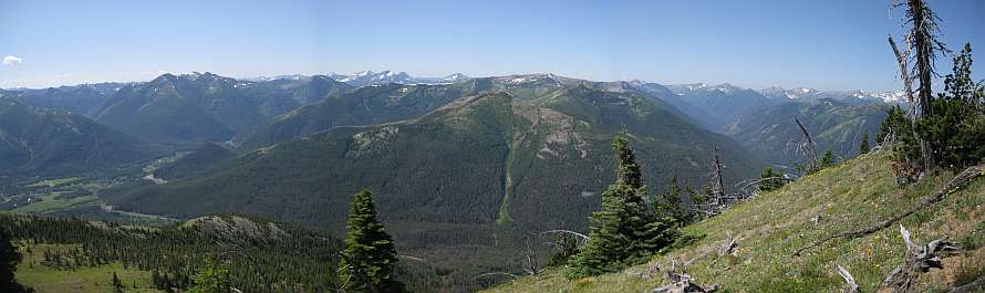
Views towards Snowslip and Running Rabbit Mountains in the center of the photo. To the right is Scaplock Mountain. All the mountains I named are in green.

A better view of Scaplock Mountain is on the right. We could see the lookout when using binoculars. The Scaplock lookout is above the white spots on the green mountain, just right of center. I've been up Scaplock Mountain twice: once in the Fall and once on snowshoes February or March 2010. The water at the bottom of the valley is Ole Creek.

This view of Scaplock Mountain shows how steep Elk Mountain is.

Nearing the false summit.


Elk Mountain top as seen from near the false summit.

Climbed some more and still not much closer. Trail is steep. The very strong wind didn't help.

The view at the top.

In case you overlooked it, this is the location of the old lookout. Glacier Park built the lookout in 1930 and destroyed it in 1963. Not much area at the top of Elk Mountain. The lookout took up most of it.

Little Dog Mountain.

Sheep Mountain. Brave Dog Mountain. And more. The trail at the bottom of this valley eventually leads to Ole Lake, then Firebrand Pass to the right of the photo, and Scaplock Mountain to the left of the photo.

You may have noticed it sticking up in the background of several of the earlier photos... Mount St Nicholas.


A number of trains came by when we were on Elk Mountain. The trains were very long and mainly carried shipping containers. Click on the photo to get a larger view to see the train going around the multiple bends. The engineer can't see the end of the train.

It was windy at the top, but not as windy it had been between the false summit and the top.


Another person's description and photos of Elk Mountain: http://www.summitpost.org/elk-mountain/425406
Jake, who I hiked with last month, posted a 3 minute video of his hike up Elk Mountain earlier this year: Jake's video.

No comments:
Post a Comment