
 Sunday August 9 I hiked with Patti and Gene to Cosley Lake in Glacier Park for a total distance of 17.6 miles.
Cosley Lake is in the Belly River region of the Park which is the very NE part of the Park and the furthest away from Kalispell.
Because the drive to the trail head is three hours one way we left at 6 am. Or 6:15 am. Patti was a few minutes late.
The sky around Kalispell was overcast. The previous night I saw lightning flash over the Park and the weather radar showed rain slipping across the border from Canada and go down into the Park.
In the morning I had checked the web cams on the east side of the Park and they showed a few clouds over the mountains but otherwise a clear day. Still I decided to bring some extra clothes in case it was cold and wet where we were going.
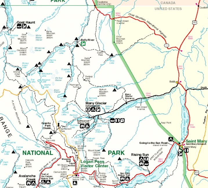
There was little traffic in the Park as we drove on the Going-to-the-Sun road. Our problem the last few miles before Logan Pass was driving up into the clouds. The clouds were so dense I didn't realize we were at Logan Pass until we were there. Patti drove slow because we couldn't see. A bighorn sheep came walking down the middle of our lane and we had to move over to let him pass by.
As we drove down the east side of the Pass we quickly left the clouds and fog behind. The bright sun blinded us.
The highway forked to the left and Patti - who never been north of Baab before - asked me which way to go. I said straight. Ten miles later we realized that was the wrong answer. We were at the Canadian border far sooner than we should have been as it was the wrong border crossing.
Patti had stopped and I told her to backup to turn around. She saw some cars coming and didn't want to back up. So she drove onward. Before we actually crossed the border there was a place to turn around and she took it. However that led to going through the U.S. custom station even though we never left the U.S. *argh*

Naturally as we never planned on leaving the U.S. none of us had our passports. We explained what had happened so he used our driver's licenses to verify our identities. He said what happened to us was quite common. We drove the six miles back to the turnoff we should have taken.
Lots of free range cattle were along the sides of the road including one big bull so Patti had to pay extra attention when driving.
We drove near Chief Mountain on the way to the trail head.

At the trail head - just south of the U.S. border crossing of Port of Chief Mountain - the large parking lot was over half full. There were far more vehicles than we expected. Another car arrived when we did and was full of 20-somethings. The women who got out of the car to use the restroom were unusually loud for the early hour of 9:15 am and were yakkety-yakking non-stop.
The morning was cool but dry. I decided to hike in my t-shirt and shorts. I didn't pack a pair of long pants as backup. When we started out in the cool morning I was questioning my decision but it turns out I didn't need any more clothing as I warmed up as I hiked and the day warmed up to the upper 60s.
The trail starts out by going down steeply for a mile and a half to two miles. That wouldn't be so bad except we would have to hike back up that at the end of our hike.

We hiked in a forest that was a mix of pine and aspen trees. The trees were not tall like in other parts of Glacier Park but they were all healthy with no signs of browning needles like elsewhere. Once the trail leveled out we hiked in a mix of meadows and trees with plenty of open areas to have views of the mountains.
Our destination was the valley left of center.


This photo was taken near the ranger station, hence the fence for the livestock. The valley here leads to Elizabeth Lake. We didn't go there. Instead we went to the right of the mountain.

There were a lot of serviceberries along the trail from near the trailhead all the way to Cosley Lake. While serviceberries are supposed to be the same as the Juneberries I have eaten in North Dakota I think the difference in soil and climate makes them taste different. Juneberries have a good flavor while serviceberries has a flatter taste. People used to huckleberries don't bother with serviceberries.
There were no huckleberries along this trail so I munched on the ripe serviceberries. The bushes were a combination of ripe and green berries but I found plenty of berries to slow my hiking speed down. Neither Gene or Patti ate the serviceberries.


By the time we reached the Belly River ranger station at noon, and after 6.1 miles, I was hungry and my energy level was low. We stopped at the station and spoke with the ranger briefly as he was in the middle of making his lunch. We found the picnic table at back of the buildings and ate our lunch there.
Two photos of the ranger station. Interesting how the view of the mountains behind the ranger station changes when the perspective of the second photo is of looking down on the ranger station.


The station had three horses nearby and after taking photos of them Patti got some crackers from me and fed the one that came to her. I told the horse that while Patti was feeding her the crackers I was the one who provided them.
This photo shows the hikers gate. Apparently the horses can't bend their way through it.

After crossing a long wooden swinging bridge over the Belly River the trail climbed into trees once again.


We took a short side trip to Gros Ventre falls. They were quite beautiful. Gene knew how to pronounce Gros Ventre and what it translated to in English. Patti and I mangled it as we don't know French.

We didn't take the side trail to Bear Mountain lookout. We had met four or five guys on the trail backpacking out to the trail head and they told us that 1.7 mile trail was steep. The photo below doesn't do justice to the height of the mountain with the lookout.

At the Ptarmigan Trail junction I went the short distance to where the trail crossed the river to revisit a memory. Back in 1992 when I had backpacked to Elizabeth, Cosley and Glenns lakes, Jeff, Denise and I had taken this cutoff trail between Elizabeth and Cosley lakes and forded the river holding on to the cable.
The cable is still there though quite new. The river level is much lower now than then. Back then the cable was nice to hold on to. Now it wouldn't be necessary.

It was a little over a half mile to Cosley Lake from the Ptarmigan trail junction. Patti and Gene got there well before I did as I encountered a number of serviceberry bushes full of ripe berries.
Cosley Lake was larger than I remembered or expected.

I couldn't remember if I had camped at Cosley or Glenns Lake back in 1992 so I checked out the Cosley campsites and food preparation area. Nothing looked familiar. Later I met a female ranger and I quizzed her on the Glenns Lake camping site and her description matched my memories.
We walked along the lake on the gravel beach before settling down for lunch. This was a short lunch as the time was around 2:30 pm. Including our 45 minute lunch break at the ranger station it had taken us over five hours to hike here. That didn't bode well for us getting out and home at a decent time as we had to hike up and out.
Patti set a steady pace on our hike back to the trail head. Whenever I would stop to talk a while with the
- female ranger (even though the ranger station looks like it could have been a ranch converted to a ranch station when the Park was established, she said it always has been a ranger station)
- young Minnesota couple starting their week long backpacking trip (with all the rain later in the week I wonder if they completed their trip or bailed along the way?)


Once we got to the start of the climb to the trail head Patti turned over the leader role to me to set the pace going up. She wanted someone to set a fast pace. I did.
It took us three hours and ten minutes to hike back out. It took us 35 minutes to hike back up the mile and a half to two miles while it took us 45 minutes to hike down that same section in the beginning.
We were back out by 6 pm. There was time to stop at a restaurant after all.

 Since none of had ever eaten at the Cattle Baron Supper Club in Baab we decided to try it. The outside of the building didn't look too promising and some people Patti had talked to earlier claimed it was spendy but we were pleasantly surprised. It was no more expensive than eating at a nice steak place in Kalispell and the inside was very nice and quite large.
The restaurant had a very large tree trunk going from the first floor up to the ceiling above the second floor where the restaurant is located.
And the food was excellent. I had chicken, and while it was good, it was the wrong decision once I tasted Gene's steak dinner. Yum! The portions were large. While Patti took her remainder home for lunch the next day I finished Gene's steak.
Our server was from Bulgaria and had a beautiful name, which typical for me and names, I have forgotten already.
The Many Glacier valley was full of clouds as we passed by on our drive home but the other valleys and Logan Pass only had a scattering of clouds. Patti got stuck behind a Chrysler PT Cruiser while driving along Lake MacDonald where one can't pass. This vehicle was driving five to ten miles under the 40 mph speed limit. *argh!*
 Don't drive behind any vehicle with a number of large butterfly decals plastered on it.
I never got home until 10 pm. A long day, but a good day.
The difference in hiking in and out were noticeable. Compare the photos of the mountains at the beginning of this post with these photos taken on our hike out. There were over 700 forest fires burning in British Columbia, Canada and the smoke was making our skies hazy.


Lastly, we saw a deer during our hike out.


No comments:
Post a Comment