It is almost the end of 2015 so I better write up the final un-written hike of 2015.
After all these years of looking at it, I
finally climbed to the top of Columbia Mountain. On Sunday
May 24 Patti and I hiked up Columbia Mountain.
Back in the Fall of 2012 I attempted to hike to the top but due to a lack of time wasn't able to.
http://tallpineshiker.blogspot.com/2012/10/columbia-mountain.html
Columbia Mountain stands at 7,234 feet tall. This is a brutal trail with a 4,000 feet elevation gain and a total
round trip of a little over 12 miles. There is also an elevation loss of several
hundred feet in the first 2 miles and then that elevation loss is
regained fairly quickly. So you are talking about a total elevation
gain/loss of close to 9,000 feet in this round trip.
The diagram gives you an idea of the steepness of the hike. To me the profile doesn't seem quite right. Now that I own a GPS unit I will have to re-hike the mountain next year.
On May 24, from the valley, it appeared that the Winter snow was gone from the part of the mountain with the trail.
Wrong! We encountered snow near the top.
Patti was reluctant to hike on the snow covered trail but I convinced her to continue on as there were breaks in the snow where the trail was snow free. The snow free areas quickly got smaller and less frequent. Patti declared with resolve that she would not go any further when we came to the next snow area. I was ahead a short ways, and when I came to where the snow area was continuous I continued on in a quick attempt to get to the top as we were very close to the top.
I made it to the top to see the views into Glacier Park and over to Hungry Horse Reservoir. While I called down for Patti to continue on she turned back. She said she heard/seen some animal ahead between where the continuous snow began and the top junction with Alpine Trail 7.
Distance: 13 miles for me. 6 miles to the Alpine 7 trail, and about another tenth or two to the top with the views. Also, at one point I doubled back to search for Patti's missing bear spray canister.
 |
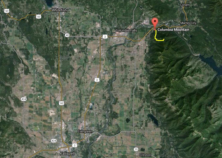
| I believe "X" marks where I ended up on top for the views. |
We had a small creek crossing. Patti walked through the water. I crossed using the fallen tree. We think somewhere around here is where Patti lost her bear spray. Later when she realized it was missing I hiked a little ways back down the mountain to find the canister. I wasn't able to find it.
Partway up. The mountain mainly in the sunlight is Teakettle Mountain. Glacier National Park mountains are in the background.
 |
| Looks like some snow up top. |
 |
| Yup. Snow on the trail. |
 |
| Glacier National Park mountains are in the background past Teakettle Mountain. |
 |
| In the beginning there were breaks in the snow. No breaks near the very top. |
 |
| Junction with the Alpine 7 trail. |
 |
| From the trail junction, the spot with views are just beyond those trees. |
 |
| Flathead Valley seen from partway up the mountain. |
 |
| Flathead Valley seen from the top of the mountain. |
 |
| The ranch is over that way. (You need binoculars to see it.) |
 |
| Columbia Falls (left of center). The now closed aluminum plant is right of center in the sunlight near the river. The plant is next to Teakettle Mountain. |
 |
| Looking SW along the top of the mountains - the Swan Range. |
 |
| Hungry Horse Reservoir. The large tall mountain covered in snow: Great Northern Mountain. |


No comments:
Post a Comment