Saturday, November 6, 2010

Numa Ridge Lookout

Last Saturday Patti and I hiked up to the Numa Ridge Lookout.  The weather was not ideal, but with Winter soon coming there are few chances of having a better weather day.  Saturday's weather was not bad, but mainly cloudy.

It appears two weather systems were jockeying for position and they met over Bowman Lake.  Darker clouds came from the left and lighter clouds came from the right.  They met over the middle of the lake then moved north to Canada.  It made for an interesting photo.

Note the mountains on the right.  A later photo will show them from another angle.


Here is a closer view of the left side of the previous photo.  My destination.  Looks so close, doesn't it?


Here is the Lookout.  Yes, there was some snow higher up on the mountain.


The view from the lookout.  Numa Peak is to the north and Bowman Lake is to the SE.  I started the hike at the far end of the lake and climbed 2380 feet in 5.6 miles to get here.

If I remember right, those are Rainbow and Square Peaks in the middle of the photo with Rainbow Peak on the left and Square Peak the pointy (go figure!) mountain on the right.

Friday, August 20, 2010

Brian and Neil

August 15 my friend Brian and his brother came to visit me and Glacier Park for four days.  It had been three years since Brian last visited me and the Park.  This was the first time for Neil to visit the Park in over a decade.

We visited most all areas of the Park accessible by car.  We did some hiking but Neil has some health issues so our hikes were pretty minor.

We hiked to:
  • the stream near the Loop
  • the Hidden Lake overlook
  • St Mary Falls
  • Red Eagle (or Trick) Falls in the Two Medicine area
  • Fishercap Lake in the Many Glacier Area
  • around the end of Bowman Lake

Brian and I attempted to hike to the Cyclone Peak lookout tower near Polebridge, MT but it began to rain lightly just after we got out of Brian's car.  We put on rain coats and hats and started out in hopes the shower would be brief.  It wasn't.  It rained harder with each step so we turned around and quickly headed back to Brian's car.  We were wet by the time we got back inside the car.  The family picking huckleberries a short distance down the road were soaked when we drove past them again.  The man was in their pickup truck and looked wet while the woman and young child were just getting near the road and truck as they had been further up the steep mountainside picking berries.


We saw five bears in the Park keeping Brian's streak alive.  Our first bear was going through bushes above the stream near the Loop.  It looked to be a young grizzly.


While at Many Glacier Lodge people saw a mother grizzly and her two cubs on the mountain above the road.  The bears were a distance off so I sat and relaxed in the sun while others buzzed about excitedly.

The last bear we saw was at the inlet to Fishercap Lake.  I saw it first when the bear crossed into some willow bushes.  Later we all saw the bear, and definitely heard it, as it climbed through the trees above the lake.

Afterward I found some huckleberries when I went wandering off on a trail by myself.  The huckleberry bushes had signs that a bear had been through them earlier.

Thursday, August 19, 2010

Swan Range black bear

Thursday with Joyce and Sue Ann I went hiking to Strawberry Lake in the Jewel Basin.  On the way back to the car we came across a back bear just off the trail.  We kept our respectful distance from one another and everything was fine once we went on our separate ways.


Saturday, July 31, 2010

Eureka Bubba Burger

Today after a day of hiking near Eureka, MT, Patti, Mary and I drove to Eureka to try the Bubba Burger that won the contest for the best burger on the "Live! with Regis and Kelly" TV show back in 2009.

The Bubba Burger is a mesquite-fired patty topped with spicy Cajun sausage, jumbo shrimp, chipotle sauce and cheddar cheese.   It is different and pretty good.

The burger is served at the restaurant called The Cutting Board which is located downtown Eureka on the main road (Hwy 93).   The restaurant is larger than I expected and is tastefully decorated.  The service was fast, friendly and attentive.

While Patti and I each had a Bubba Burger, Mary - who leans towards being a vegetarian - had a chicken sandwich with grilled vegetables which included mushrooms, carrots and beets among other vegetable.  The taste I had of it was delicious.  Mary really liked it and said she could have had just the grilled vegetables as a meal and she would have been happy.

All the food was very good.

We left shortly after 9 pm as we wanted to get back to Kalispell before it got too dark.  Hwy 93 between Eureka and Kalispell is known for having lots of deer along the road.  Therefore we left before the owner got ready to play his guitar for the enjoyment of the customers.

Saturday, July 24, 2010

21.2 miles and Gall

Today I went hiking with Gene and Patti in the Jewel Basin. We saw six lakes. Patti and Gene said the route would 16 miles long.  At the beginning I calculated on the map that our route would be 18 miles.  We missed one turnoff and ended up hiking an extra 3 miles in total.  At the end I recalculated our route's distance and the total was 21.2 miles.  No wonder I feel tired now.

In the trail head parking lot was another unusual car window sticker.  It is not just hippies/liberals who hike and put stickers in their car windows.

Saturday, July 10, 2010

How Minnesotan's gather firewood

Saturday I went with friends on a hike to Upper Quartz Lake in Glacier Park.  It seems as if I can't visit Glacier Park without seeing someone from Minnesota.  Apparently this MN person took a corner too fast on the Bowman Lake road and went into the ditch.  He came out with this log.

Saturday, June 19, 2010

Gunsight Lake and death

Saturday I joined Leah's hiking group for a hike in Glacier Park.   We planned to hike the south side of St Marys Lake - a hike I've wanted to do for a while now - but we had to change our plans.  Our route would have taken us past Virginia Falls and over a bridge where a woman fell off on Friday.

The number one cause of death in Glacier Park is not bears, but from drowning.
A 62-year-old Missouri woman drowned Friday June 18 after she fell from a bridge downstream from Virginia Falls and was carried away by a fast-flowing creek in Glacier National Park.

According to a witness accounts, the woman and her husband were walking across the bridge around noon Friday when she slipped and fell about four feet into cold, swift Virginia Creek.

She was quickly carried away by the current and her husband lost sight of her. Authorities say the 40-degree water would have made it difficult to survive very long.

About 20 park staff and a helicopter crew searched the stream for the rest of the day but her body wasn't found until Saturday when a dive team located it wedged beneath a bridge.

As we drove past the St Marys and Virginia Falls trail head on Saturday morning it was closed to public use due to the search and rescue work in finding the woman's body.  So we switched our plans and hiked to Gunsight Lake with a side trip to Florence Falls.

The Park signs said it was 6.2 miles to Gunsight Lake but Mitch's Garmin Oregon GPS unit said it was 5.1 miles.  A mile difference is a bit much.  Could the park be that wrong?  Nope.  Mitch later found out his Garmin unit needed a software or firmware fix.   The side trip to Florence Falls was listed at 1 mile.  So I hiked 14.4 miles.


Reynolds Creek


Florence Falls


Gunsight Lake.   Although at this time of year it could also be called Iceberg Lake.
Gunsight Pass is through the "V" left of center.  Obviously it would be difficult to cross this time of year.


And yes, I hiked a little bit on snow near the lake.

Friday, June 18, 2010

Clearing snow in June

 Glaicer Park is still clearing snow off the Going-to-the-Sun road.  The second half of June!  Aren't we suppose to be in Summer by now?  Please give me my global warming back!

http://www.flickr.com/photos/glaciernpsnews

Sunday, April 18, 2010

Winter snow hiking photos

This is on the hike to Apgar Lookout on February 28 with Joyce and Patti.


This is near the top of Ousel Peak on March 14 with Patti.  Glacier Park is in the background.  I actually used my snowshoes on this hike.


April 18 I attempted to hike up to Huckleberry Lookout in Glacier Park. Patti and I were the first people up on this trail this year as there were no other human footprints in the snow.  We turned back when the snow on a very steep slope in an open section started to make settling noises in a ten foot radius a number of times when I made a step.  A week or so ago a guy died in an avalanche while skiing/snowboarding on a mountain in another part of the Park.  We decided not to risk it and never got close to the lookout.

Sunday, March 21, 2010

North Fork elk

Saturday when driving up the North Fork Road to go to Bowman Lake, Patti, Joyce and I came across these three elk along the Flathead River.  After a bit they decided to cross the river.


Saturday, March 20, 2010

Bowman Lake sounds

Saturday Patti, Joyce and I hiked to Bowman Lake.  Yes, I said 'hiked'.  No cross country skis.  No snowshoes.  We just needed Yak-trax the last third of the hike when we got into the trees and the road got a little icy. Prior to that we were in the burn area from the 1988 fire which is mostly open.  There the road was mostly snow free except for shaded areas.  It is six miles from the park entrance to the lake.  The road is closed over the winter.

A new experience for me was...  the lake made sounds.  From under the ice.  As we got near the lake, and before we could see the lake, we thought we could hear the sounds of a dull boom-boom of music from a stereo or boom-box.  Huh?!   Once we reached the lake we learned it was the lake making the deep booming or thudding sounds.  Wow!

The sound was loud enough to be unmistakable.  And consistent.  The sound, which came from all around our end of the lake, lasted the entire time we were at the lake which was over an hour.  It was not the sound of ice cracking.  I don't know what was causing the sounds. Maybe the lake water was bumping up against the ice?  I never have heard anything like it before.


The view of Glacier Park from Polebridge, MT.


Sunday, February 21, 2010

Mt Brown lookout in snow

Sunday February 21, under a clear sky, I hiked up to the Mt Brown Lookout in Glacier Park.  This trail is the steepest trail in the Park.  I climbed 4,305 ft in 5.8 miles.  The maximum elevation was 7,487 ft.

Needless to say I was tired after the 11.6 mile hike of almost 8 hours (though to be fair I spent over an hour up at the lookout).
 
The hike was all in snow.  Enough people had used snowshoes to get to the lookout that the snow was packed enough that I was able to reach the lookout without using my snowshoes.  I did carry them on my back the entire way as I thought I may need them when I got on high.

Leah was also at the Park on Sunday and took the following two photos.  I believe the lookout is where I marked the photo with the red O.  I started the hike at the lake level.  Mt Brown is the mountain behind the lookout.  That is about 7 miles away.


Here is the view from near the trail head at Lake McDonald.  The lookout is the white bump under the u in 'Lookout'.  In this view you can see the mountain with the lookout is separate from Mt Brown.  The final photo also shows that.


The views were great and I took 200 to 300 photos.  I haven't had time to go through them to weed duplicates and bad photos and to stitch other photos together.  But here are a few photos.

Lots of snow up there!


Leah's first photo was taken at the far end of Lake McDonald near Apgar Village.  That is about 7 miles away.


The mountain just under and to the right of the snow hanging from the lookout roof is Huckleberry Mountain.  I don't remember if I wrote about that hike that I did last Fall.  As you can see there is so much snow that the walkway around the lookout was filled to the railing level.


Photo 1: the rightmost peak of the three peaks is Heaven's Peak.  I forgot the names of the other two peaks.
Photo 2: Mt Brown

Wednesday, February 10, 2010

Blue

Blue skies lead to a blue mood?

Yesterday Joyce and I drove 100 miles and crossed the Continental Divide in search of a blue sky.  We found it once we reached Maria Pass.  The mountain tops held the clouds back and it was solidly clear and blue to the east.

Sun!  Oh, glorious sun!

Around East Glacier everything was coated in a thick frost.


We skied 7 miles to Two Medicine Lake and close to the shadows from the clouds trying to get past the mountains.  The wind brought occasional snow flakes flying floating by.

Late afternoon we watched the looming clouds and anticipated the loss of sunlight as we drove back to and under the massive line of clouds.  Even after we entered the cloud's shadow we could still see the snow covered mountains to our side lit by the sunlight.  Then all traces of sunlight were gone.


Today I have a 'hangover' from my blue sky experience.  It is gloomy and gray here yet again for another day and the forecast has this forever.  I miss seeing the blue sky.

Tonight there was a story on the local weather forecast that said that the Flathead Valley has had five days of blue skies since December 1.  Only five days!  Fortunately I spent a few weeks back in Minnesota and North Dakota since December so I saw more than just five days of sun.  Still... I want more sun.

It didn't help that Leah forwarded me some photos taken by a friend of hers who hiked up to Mt Brown Lookout last weekend.  This hike is on my list of things to do this winter and I haven't made it up there yet.

Tuesday, February 9, 2010

Two Medicine ski

Tuesday, February 9, 2010 Joyce and I skied to Two Medicine Lake.  We liked the idea of visiting the lake in the Winter, but mainly we were looking for blue skies.  The Flathead Valley had only 5 full days of sun since December 1.


Once we reached Marias Pass on the Continental Divide the clouds ended and it was nothing but blue skies ahead.  Around East Glacier everything was white, having been covered by thick frost.


Once we had crossed the Continental Divide there was hardly any snow.  We had hoped to ski but also brought snowshoes and hiking boots for whatever the conditions were.  It can get windy in the Two Medicine Valley and we expected most of the snow to be blown off the road.  To our surprise we could only drive a half mile off of Hwy 49 on the road to Two Medicine.  Any more would be risking it - and Joyce didn't bring a shovel along in her car.  Probably a quarter mile down the road was the furthest any vehicle had traveled.  Judging from the broken pine branches they must have used them for traction in helping them get unstuck.


At the end of the afternoon when we returned to the car we saw fresh tracks.  That vehicle didn't go as far as seen in the above photo before they wised up and turned around.


Our destination is to the left of the leftmost white mountain (Rising Wolf Mountain) in the distance.  We had already skied a half mile to a mile when I took this photo.  Lower Two Medicine Lake is in the foreground.


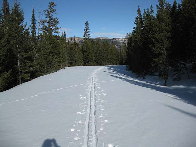
There were plenty of ski tracks in the snow.  And some foot prints.  The snow depth varied from a small amount to deep.  When the snow was deep the footprints sunk deep even though the person tried to walk in various ski tracks.  The further we went the less tracks.  By the time we reached the Glacier Park gate only a few tracks were left.


Shortly after we entered the park the snow disappeared from the road and we had to ski in the ditch.  By now there was only one set of ski tracks.  The bare road last several miles.  The ski tracks turned around short of the return of the road snow.  If they had only gone around one more bend in the road...


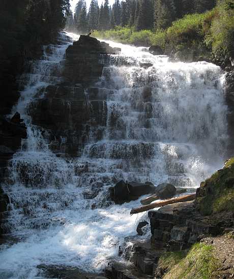
We skied the .3 mile to see Running Eagle Falls.  I was able to ski relatively close to the falls.  I even skied/climbed up to the observation platform and back down without falling into the water.  In fact I didn't crash once on this trip.  The snow was good for skiing.  The temperature was in the 20s so the snow wasn't sticky.  And there was enough to ski on but not too much to slow one down as I had to break trail.

In the summer water also flows over the top.

Running Eagle Falls


Spot Mountain

The view to the valley that leads to Pitamakan Pass.
Rising Wolf Mountain is on the left and Spot Mountain is on the right.


The road looks more level that it actually is.


This mountain is the location of the trail to Scenic Point.

The campground is Full?!!!


Rising Wolf Mountain.

Two Medicine Lake and Sinopah Mountain.

The wind wasn't too bad and probably was blowing only 10 to 15 mph.  At times we were completely sheltered from the wind.  At Two Medicine Lake we felt the wind's cold bite as we ate our lunches.

Sinopah Mountain


Skiing back to the car we had the wind at our back - and that was nice.

-