Showing posts with label Two Medicine area. Show all posts

Saturday, October 25, 2014

Upper Two Medicine Lake

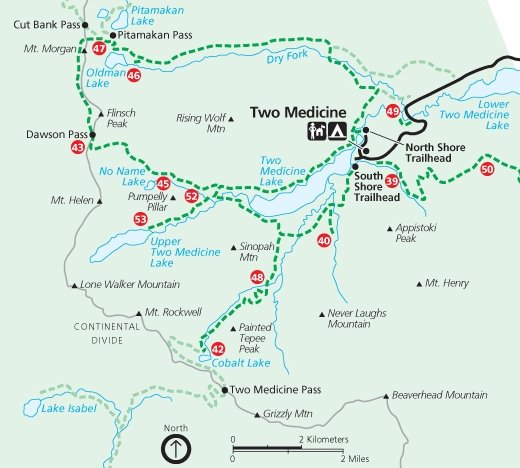
Saturday Oct 25, Patti and I hiked to Upper Two Medicine Lake.  This hike was chosen for several reasons:
  1. It was opening day of hunting season and Patti felt safer hiking in Glacier Park where hunting is not allowed.
  2. As a change of pace Patti wanted to hike to a lake instead of a mountain top.
  3. We hadn't been on the east side of the Park this year for a hike.  Because of the shorter and shorter daylight, now is better than later for a long day of driving and hiking.
We both had hiked to Upper Two Medicine Lake before.  For me it was October 17, 2010.


As we drove along Hwy 2 through the mountains we saw lots of vehicles parked in many of the road's pullouts. Hunters were out in droves.  I later read a news story where a hunter from Minnesota and later another hunter shot at a grizzly bear that charged them near Marias Pass.  Apparently the hunters had surprised a grizzly and her two cubs who had been feeding on a poached moose and her calf.

Two Medicine Lake was mostly still as the wind was mostly calm. Unusual as the Two Medicine area is usually windy.  The upper mountains were draped in snow.   Winter is coming.


The distance to the lake is about 4.8 to 5 miles one way.  The elevation gain is not much at only 350 ft.

Red line was our route.


The temperature when we started was 37 degrees.  The sky was mostly cloudy.  It appeared like the clouds were breaking up near the start of our hike but that stopped and it was cloudy all day until shortly before we got back to Patti's vehicle.  Then the cloud bank started to leave and the sun came out.

On the trail we met Patrice.  He is originally from Reunion Island in the Indian Ocean but now lives in Seattle where he teaches at a French school.  When Patti and I saw what looked to be somewhat fresh bear scat we waited for Patrice and hiked with him for the rest of our hike.  Safety in numbers.

It was good we hiked together as Patrice had an interesting background and was pleasant company to hike with.

http://en.wikipedia.org/wiki/R%C3%A9union
http://www.reunionisland.net/


Search Google images for more awesome photos of Reunion Island.


Twin Falls (between Two Medicine Lake and Upper Two Medicine Lake) is not far off the trail so we stopped to see it.  This time I noticed a user path on the left of the left falls and followed it up the twists and turns and extra falls to almost the top of the falls.


We hoped to see moose as my previous hike to Upper Two Medicine Lake had multiple moose sitings.  No moose this time.   Here are a few photos from my previous visit where I saw moose, including the last photo where the moose blocked the trail for a while.


Other than a few birds and squirrels close by the trail, the only other wildlife seen was with Patti's binoculars. While eating our lunch at the lake I used the binoculars to spot mountain goats and two bighorn sheep up on the rocky mountainside of Pumpelly Pillar

Follow this link for more photos:

https://plus.google.com/photos/109566462412251958234/albums/6076251096230010017?authkey=CIfeoriH65aZHA


For a video of Twin Falls we passed along the way:  http://youtu.be/lNyoyUA5Q1c

For a video of the falls of water shortly after it exits Upper Two Medicine Lake: http://youtu.be/q7aqIFR4ics

---

Saturday, June 25, 2011

After the waterfalls

Here are some photos taken between waterfalls and after viewing them.

We first saw this car when we drove on Hwy 2 near where we saw the Silver Staircase waterfalls.  Then when we saw the car below it was after we came out after hiking to St Mary and Virginia Falls.  I guess slow and steady and eventually you'll get there.


Gunsight Valley

Along the Sun Road at the trail head after coming out of the Gunsight Trail.


Lower Two Medicine Lake

All total this day, Patti and I hiked around 16.6 miles.

Wednesday, February 10, 2010

Blue

Blue skies lead to a blue mood?

Yesterday Joyce and I drove 100 miles and crossed the Continental Divide in search of a blue sky.  We found it once we reached Maria Pass.  The mountain tops held the clouds back and it was solidly clear and blue to the east.

Sun!  Oh, glorious sun!

Around East Glacier everything was coated in a thick frost.


We skied 7 miles to Two Medicine Lake and close to the shadows from the clouds trying to get past the mountains.  The wind brought occasional snow flakes flying floating by.

Late afternoon we watched the looming clouds and anticipated the loss of sunlight as we drove back to and under the massive line of clouds.  Even after we entered the cloud's shadow we could still see the snow covered mountains to our side lit by the sunlight.  Then all traces of sunlight were gone.


Today I have a 'hangover' from my blue sky experience.  It is gloomy and gray here yet again for another day and the forecast has this forever.  I miss seeing the blue sky.

Tonight there was a story on the local weather forecast that said that the Flathead Valley has had five days of blue skies since December 1.  Only five days!  Fortunately I spent a few weeks back in Minnesota and North Dakota since December so I saw more than just five days of sun.  Still... I want more sun.

It didn't help that Leah forwarded me some photos taken by a friend of hers who hiked up to Mt Brown Lookout last weekend.  This hike is on my list of things to do this winter and I haven't made it up there yet.

Tuesday, February 9, 2010

Two Medicine ski

Tuesday, February 9, 2010 Joyce and I skied to Two Medicine Lake.  We liked the idea of visiting the lake in the Winter, but mainly we were looking for blue skies.  The Flathead Valley had only 5 full days of sun since December 1.


Once we reached Marias Pass on the Continental Divide the clouds ended and it was nothing but blue skies ahead.  Around East Glacier everything was white, having been covered by thick frost.


Once we had crossed the Continental Divide there was hardly any snow.  We had hoped to ski but also brought snowshoes and hiking boots for whatever the conditions were.  It can get windy in the Two Medicine Valley and we expected most of the snow to be blown off the road.  To our surprise we could only drive a half mile off of Hwy 49 on the road to Two Medicine.  Any more would be risking it - and Joyce didn't bring a shovel along in her car.  Probably a quarter mile down the road was the furthest any vehicle had traveled.  Judging from the broken pine branches they must have used them for traction in helping them get unstuck.


At the end of the afternoon when we returned to the car we saw fresh tracks.  That vehicle didn't go as far as seen in the above photo before they wised up and turned around.


Our destination is to the left of the leftmost white mountain (Rising Wolf Mountain) in the distance.  We had already skied a half mile to a mile when I took this photo.  Lower Two Medicine Lake is in the foreground.


There were plenty of ski tracks in the snow.  And some foot prints.  The snow depth varied from a small amount to deep.  When the snow was deep the footprints sunk deep even though the person tried to walk in various ski tracks.  The further we went the less tracks.  By the time we reached the Glacier Park gate only a few tracks were left.


Shortly after we entered the park the snow disappeared from the road and we had to ski in the ditch.  By now there was only one set of ski tracks.  The bare road last several miles.  The ski tracks turned around short of the return of the road snow.  If they had only gone around one more bend in the road...


We skied the .3 mile to see Running Eagle Falls.  I was able to ski relatively close to the falls.  I even skied/climbed up to the observation platform and back down without falling into the water.  In fact I didn't crash once on this trip.  The snow was good for skiing.  The temperature was in the 20s so the snow wasn't sticky.  And there was enough to ski on but not too much to slow one down as I had to break trail.

In the summer water also flows over the top.

Running Eagle Falls


Spot Mountain

The view to the valley that leads to Pitamakan Pass.
Rising Wolf Mountain is on the left and Spot Mountain is on the right.


The road looks more level that it actually is.


This mountain is the location of the trail to Scenic Point.

The campground is Full?!!!


Rising Wolf Mountain.

Two Medicine Lake and Sinopah Mountain.

The wind wasn't too bad and probably was blowing only 10 to 15 mph.  At times we were completely sheltered from the wind.  At Two Medicine Lake we felt the wind's cold bite as we ate our lunches.

Sinopah Mountain


Skiing back to the car we had the wind at our back - and that was nice.

-

Friday, September 28, 2007

Dawson Pass to the end

At Dawson Pass we now looked down into the Two Medicine valley and could see the Two Medicine Lake miles below.


We still had snow on the other side of Dawson Pass but as we dropped down from the top we dropped out of the wind. That was a blessing. The snow did not cover everything but I still used the snow to go down faster than just following where the trail lay under the snow. We had to make time. It was after 5 pm now and we had almost 6 miles yet to hike.

Because the trail dropped so quickly it wasn't too long before we were out of the snow. It seemed as if we had hiked half the trail in snow.

Photo 1: the south side of Flinsch Peak. From this side it looks easy to climb. Look at the previous posts to see the peak from the other three sides. I think I will return next year and climb it.

Photo 2: many layers of rock.


At a trail junction the sign said the distance to No Name Lake was .2 mile. I decided to hike to the lake. Joyce and Sue Ann continued back to the car. I was confident I would catch up to them as I had been hiking faster than them.

No Name Lake should be renamed. Maybe "Reflection Lake". The lake is not very big but the water reflected the views from all sides. I could see the rock mountain side to the south, the permanent snow field to the SW, the far off snow covered mountain to the east, Rising Wolf Mountain to the north, in addition to the trees along the lake. Very beautiful.

Photo 1 shows No Name Lake from near Dawson Pass.


Of the photos below, which is Rising Wolf Mountain and which is its reflection in the lake? Can you tell?  You never know... I may have inverted some of the photos to make it more challenging.


Between taking a large number of photos I also spent time checking out the campground and environs beyond the lake. I spent more time here than planned, but well worth it.

From near the lake here are views looking back to Dawson Pass and then later a view of Two Medicine Lake. I had thought I would be closer to the lake at this point with all the hiking I had done.


I never caught up to Joyce and Sue Ann before they reached the car. In fact they reached the car almost 20 minutes before I did. They were determined to get off the trail before dark.

Through the trees I could see mountain tops to the east lit up by the setting sun. Once it became open so I could take a photo that light was gone. Then I noticed the clouds west over the Pass were a light rosy orange. Again trees prevented a worthwhile photo. Next I noticed the clouds above the eastern mountains were lit a fluorescent orange. Again I had trees in the way making a photo pointless. My timing was off. Sue Ann later said they were in an open area along the lake at this time and the lake was a beautiful red in the light.


At one point when I was along the lake I thought I heard a sound in the trees below.

"Hey bear. Hey bear!" I called out. No answer.

As I moved along I heard more sounds like some animal also walking along with me. The hairs stood up on the back of my neck. It was dusk, the time the wildlife comes out to eat. I kept walking and after a minute I no longer heard any more of the sounds.

A few stars were now visible in the sky and the trail was getting hard to see when it was in amongst the trees. Across to the SE end of the lake I could see lights from the campground store and employee quarters. Getting dark!

The trail head was actually at the campground end of a short spur trail that led from the campground to where the Dawson-Pitamakan loop started. I really watched for this short trail as I definitely didn't want to begin the loop again! I was able to make out the trail sign in the darkness. *whew!*

I couldn't tell where the car was until I got closer. It also helped that Sue Ann opened the car trunk to get something and I could see the trunk's light. Joyce's car was the only one in the parking lot. The two hikers still on the trail must be staying in the campground. Even if it would be a chilly night, a tent and sleeping bag and not a long drive home, seemed like a great idea.

Joyce and Sue Ann reached the car at 7:55 PM, and I at 8:15 pm. It took us 11 hours to do the hike. Our Gunsight Pass hike was over a mile longer and we did that hike in only 10 hours. Then again we had no snow on Gunsight Pass and less elevation to climb.

Joyce and Sue Ann were very tired. Me, not so much. So I drove Joyce's car back. Besides I usually stay up late and would be less likely than the others to fall asleep during the drive home.

All of our shoes, socks, feet and pants were soaked. Joyce cranked up the car's heater and it was a toasty warm drive home. As this was an unfamiliar car I drove 5 to 10 miles under the speed limit home. Even so we didn't see many other vehicles on the road and were only passed by two vehicles between Two Medicine and Columbia Falls. For those who are unfamiliar with the area, I believe this is roughly 75 miles.

The answer to my lake reflection question is that the third photo is the mountain itself.