Sunday, October 14, 2012

Columbia Mountain

Sunday, October 14, I hiked up Columbia Mountain with Patti and Mary.  Patti and I had never hiked on Columbia Mountain even though it may be one of the closest and easiest hikes for us to reach.  I see the mountain every day out my front window.

Teakettle Mountain is on the left.  Columbia Mountain is on the right.

Easiest to get to doesn't mean it is the easiest to hike on.  This trail went up from the get go.  What is worse than going up is... going up, then going down before going up again.

Mary said the trail originally started a mile to the south.  But the trail access was through private property.  The Forest Service then built and extended the trail thru public property to the north to the current trail head.  The trail extension is the reason for the up and down (to connect to the original trail).

I don't know why, but the elevation profile on the right doesn't show the down section of the trail a mile or so into the hike.  I need to get a GPS unit to accurately map the trails I hike on.  And if you compare the elevation profile to the first photo, it also doesn't look like it matches.


Fall colors.


Columbia Falls is on the left side with Teakettle Mountain on the right side.


This is not the waterfall.


Here, and later above the waterfall, were some makeshift memorials to someone.


Here is where the waterfall stream crosses the trail.


Stream below the waterfall


I climbed up above the waterfall.


More photos from above the waterfall as I followed the stream a good distance before quitting and turning back to Patti and Mary.


We continued up the trail after the waterfall side trip. 


Our late start, the long time spent exploring the waterfall, and Patti's 4:30 pm commitment meant we couldn't make it to the top of the mountain today.  I don't know what we all were thinking as this was more of a hike (climb) than we anticipated. Our underestimation of the hike may because we see the mountain everyday.

Patti and Mary turned back.  I went up the trail a little more as Mary said there was a break in the trees and a view of the Valley up ahead.  Here is where I stopped.  At the point where I could now see how far I was from the top.   Or near the top.  I don't think what we are seeing is the very top of Columbia Mountain.

I included both photos to give you an idea of just how far I had left to hike.  The second photo shows the distance better.


I booked when I hiked back down the trail in order to catch up to Patti and Mary.  They were waiting at a viewpoint a little over a mile from the trail head and said they had not been waiting very long.


There are not a lot of views along the trail due to the trees.  Here are a couple photos of the Valley.

Columbia Falls

Looking towards Kalispell


The video of various parts of the waterfall is 4:37 long.

https://www.youtube.com/watch?v=4K5dPD6tVhE

Friday, October 12, 2012

Bowman Lake

Friday, October 12, after we hiked to Logging Lake in Glacier Park, Patti, Patti's co-worker Jerry, Joyce, Bill's niece Cheryl, and I drove over for a quick visit to Bowman Lake as Cheryl had never seen the lake.  Bowman Lake is one of my favorite lakes in the Park.


Rainbow Peak and Square Mountain.  Square Mountain is the smaller pointy mountain in front.


Rainbow Peak


Zooming in to the far end of Bowman Lake.  The "Hole in the Wall" area is just left of center.


Logging Lake

Friday, October 12, Patti, Patti's co-worker Jerry, Joyce, Bill's niece Cheryl, and I hiked to the first campground on Logging Lake in Glacier Park.  I had never been here before.


It was 5 miles to the first campground.  As you can see from the sign below, Logging Lake is a long lake.  Someday I will go further.  Maybe all the way to Grace Lake.


The elevation change is not much.


It was a cool morning with the temperature in the lows 30s when we started.  But the sun burned out the fog and it soon warmed up and people began to shed their jackets.

We soon walked through the remnants of an old fire.  I believe this was the Wolf Gun fire from 2003.


I never noticed it until now but Logging Lake is almost the same latitude as the most northern part of the Going-to-the-Sun (the Loop area).  The long drive up the North Fork road to get to Logging Lake, and the remote area, makes one think they are further north than they actually are.


On the hike back to the car we heard a few howls by a wolf some distance away.  Here we are listening for the howls and looking for signs of a wolf.


The Park employees had chainsawed quite a number of downed trees along the trail.


Three tenths of a mile from the campground is a ranger patrol cabin. We ate our lunch on the picnic table in front of the patrol cabin.


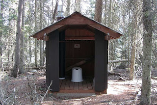
Here is the patrol cabin's outhouse.   Fancy... but they forgot the door.  Another suggestion...if they leave the door off, turn the outhouse around so the people could have a view of the lake while tending to their business.


Near the outhouse were two pile of branches stacked as shown. It looks to be a slash pile for burning.  But they wouldn't do that in the Park would they?  And certainly not so close to other trees.


Logs from a tree cut down next to the patrol cabin.


The view up the lake from the patrol cabin.


The campground only has three sites.


View of the lake from the campground.


At the campground we got a fire going.  Last time Patti was here she didn't notice many sticks and branches for burning so she asked me to pack some firewood along.  We were able to easily find more dead wood for the fire.


We roasted marshmellows and made S'mores from the ingredients that Patti brought along.


Patti and Jerry each brought a bottle of wine to have with our S'mores.  Here is one of the S'mores I made.  Some people ate plenty of S'mores and got a sugar buzz.  The wine had nothing to do with it. 


Video of the group making and and eating S'mores at the campfire.  21 seconds long.

http://www.youtube.com/watch?v=qZfBQcxvEZM


Near the campfire area was a metal can for watering.  The sign said it was for watering the small pines trees planted near the can.  We found the can to be handy to completely put out the fire before we left and returned to the car.


Here is how we fill the can with water.


Here is the bridge one crosses to pass from Polebridge into Glacier Park.