

Jim forgot to turn off his GPS app when we got back to the trailhead so I am estimating our total mileage at 8.5 miles and the elevation gain at 4500 ft.
Driving two vehicles we left Kalispell shortly after 6 am. We were delayed on our drive down the Swan Valley because we had to stop at a coffee kiosk near Woody's so Bob could get a foo-foo latte. He lives near Seattle so I think they are required to drink foo-foo lattes.
 The kiosk hadn't finished brewing that day's coffees so we had to wait a little bit.
On Montana Hwy 83, about 2 miles south of Condon, MT (mile marker 39) we turned east on the Rumble Creek Rd. We followed that road four miles to parking area, which is a quarter mile or so past the Cooney Lookout Tower.
We were on the trail shortly before 8 am.

In the photo below is a group of young backpackers planning to camp at Upper Rumble Creek Lake. An indication of the slower speed we hiked at, we never caught and passed this group. When we were heading out from Lower Rumble Creek Lake they could be seen at the top near Upper Rumble Creek Lake, an elevation gain of almost 1000 ft between the lakes.

Forest service trail 192 doesn't have too much elevation gain. However, after about a mile, and after you cross a wooden bridge over Rumble Creek, you'll round the corner of a ridge, at which point the fisherman/climbers trail to the lakes will be on the left-hand side of the trail. This trail goes from point A to point B in the shortest way possible. Other than minor twists and turns around trees I only remember one switchback on the trail. Otherwise it goes straight up.
For comparison, think of going up Elk Mountain in Glacier for over 4 miles non-stop. Or think of hiking higher than Swiftcurrent Lookout in about 4 miles instead of 6.5 miles from the Loop on the Sun Road.
Yeah... steep!
Part of our slow progress was that once we left the forest service trail (in addition to the steepness) was that Doug, who only planned on hiking to the upper lake to fish, was ahead of me and he stopped numerous times to turn and face me for emphasis when finishing a story. We were fourth and fifth and the other three hiking members ended up stopping a few times so we could catch up. We were over 3/4 the way to Lower Rumble Creek Lake when I took the low 'road' around a large tree over the trail while he limboed underneath the fallen tree. Then I was fourth and he couldn't stop to finish his stories.
Other than some downfall - for which user paths were being created around the fallen trees - the fisherman/climbers trail was surprisingly in good condition. Not many huckleberries left but I found a number of serviceberries to munch on the way to the lower lake.
The highlight of this first section of the climb is that you have a phenomenal view of the Swan Valley, which is much bigger than I thought it to be. You don't realize the sheer size of the valley while driving through it, perhaps due in part to the dense forest. I was surprised at how many lakes and picturesque farm/estates speckle the valley floor.
The trail does moderate somewhat after a brutal 2,000' elevation gain over the first ridge.
Almost 3/4 to the lower lake you come out of the trees to an open mountain side. Don't go straight through the old landslide. Too sketchy. Instead take a hard right and drop down through the trees a short distance (which seems too long when coming back the the way and you have to climb this section!) and exit the trees on a steep trail. Coming back Doug tried to cross the landslide area instead of dropping down and climbing back up and regretted it.


Just before reaching the lower lake you have to cross the Rumble Creek over a fallen log.

Lower Rumble Creek Lake
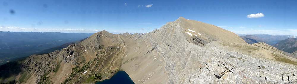
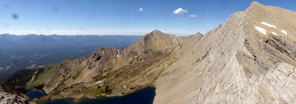
We stopped and ate a snack at Lower Rumble Creek Lake. There is a camping area with some logs to sit on near the lake.In the photo below, Holland Peak can be seen in the background just sticking up just left of center. Below the peak, in the center, is the large rocky area that acts as a dam for the Upper Rumble Creek Lake. The top of the rocky area is outlined with green/trees.

There is a large waterfall coming out of the upper lake. The waterfall is just left of center in the following photo. The upper lake cannot be seen until you are almost there. You may need to click on the photo to enlarge it to better see the waterfall. The trail from the lower lake to the upper lake goes on the right side of the lakes. The trail can be seen from the right side of the photo at the mid point. The trail goes through rocks, scree and trees and pretty much hugs the right cliffs. The trail goes up the right side of the waterfall.

Because the trail is along the north side of the cliffs, I imagine there will be snow here well into the Summer.
An overhead view of the lake on our return as Bob waits for us. Both lakes turned a gorgeous blue when viewed from above.


Lower lake to Upper lake.
The loose rock makes the sometimes indistinguishable trail to Upper Rumble Creek Lake a difficult one. We stopped many times to rest and enjoy the view before climbing further. When you reach the upper section of the waterfall, the remainder of the climb is completely unmarked. You'll need to stay to the right as much as possible, where the loose rocks meet the face of the cliff-side. You'll need to be fairly sure-footed here and keep moving so as not to slide back down.
FYI - see the green 'knob' ridge beyond the lake. The trail went straight up and over the ridge. Usually game trails or forest service trails would circle around the side of the ridge and gain elevation more slowly. Also, we started our hike at the same elevation as the brown patch off the left side of the green ridge. The open area on this side of the ridge was shown earlier in photos where I talked about going down.


Once you get this high (where we are standing in the photo below) you cut across to the left to the trees. It is a short way up and over to the lake. You pop out of the trees and the lake is right there.


The Swan Valley and the Mission Mountains are in the background.

Upper Rumble Creek Lake
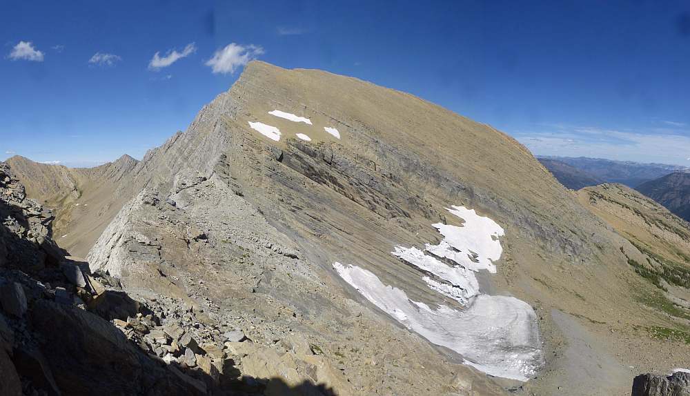
The elevation at the lake is around is 7,890 ft, almost 1000 ft higher than the lower lake. The elevation gain from the trailhead is about 3400 ft to the upper lake. My guess is that it is about three to three and a half miles to the upper lake.Now one may think the route up to the top of Holland Peak is on the left and then over to the right up to the top. Nope. The route is to the right of the photo. A later photo will show you where you leave the lake.

Upper Rumble Creek Lake from above
 |
| I was standing on the trail when I took this photo. |


Upper Rumble Creek Lake to Holland Peak
Time was getting short if we wanted to get back to the vehicles before dark. It was 1 pm now. Including the lunch stop at the lower lake it took us 5 hours to get here. We were moving slow. The plan was to leave the packs here and just take water and a few light snacks. Even so we ended having another short lunch break. By the time we got the water and snacks, etc. sorted out more time had passed. There were chipmunks about so we hung our packs on branches in the short trees.Doug stayed at the lake and fished. He claims to have caught several large fish while were gone. One fish was 20 inches long. He let them go as he didn't want to pack them out. He also didn't have a camera to take photos of the fish.
The route up is up on the right side of the photo to the top of the ridge. Then go left along the ridge around the south summit which is left of center.

You can see the start of the trail in the gravel at the bottom.

A view of Dick on our climb. Yes! This section from the lake to the top of the ridge is very steep.

A view of Jim on our return down.


High enough to see more of Holland Peak. The last bit to the top doesn't look bad. Yeah... right!

About 10 or so Mountain goats watch us as we climb. You can see one goat still has part of its winter coat. We saw bits and pieces of that coat on the trail starting at the lower lake.

Swan Valley and the Mission Mountains. Note to Brian: this is the valley you drove through on your return to Minnesota.

On our hike up we met a 60 yr old woman and a young (maybe 20 yr old) French guy. They only made it as far as most of our group later did. Jim is in blue climbing up and the couple are mid right side going down. Note: the "V" on the left edge is where we came up to the ridge top from the lake.

Still looks like the worst is over.
Hmmm... the 'notch' could be tricky.

The 'notch' is a tilted slab of rock. How to get there?
That's the Bob Marshall Wilderness in the background.

Looking back at the south summit. The 'pyramid' in the center is Buck.

Another view of the 'notch'.

See a route to the 'notch'? Keep this photo in mind to come back to.

I found a skree chute and went down it. To the left is the 1500 ft drop to the lake you had seen in earlier photos.
Opps... dead end. The shadows indicate two cliffy sections I did not want to climb down to reach the notch.

I climbed back up the skree chute to where the group had caught up to me. Jim had the following descriptions:
Ascent Trip Report
The climbers' trail is very easy to follow. Beyond (N of) the south summit, and just before the blocky slab section, descend an easy scree chute to the east. Then, to keep it class 2, cross west and traverse an easy sidewalk ledge across the top of the 1,500' west face before regaining the blocky slabs and moving to the base of the straightforward summit pyramid.
Another Trip Report
Here's my recommendation to future climbers negotiating the rocky ridge on Holland:
When you reach the first dropoff at the N edge of the flat talus-and-tundra summit plateau of the S peak, proceed a short distance R (E) until you find a talus slope that you can descend. This avoids a sketchy and exposed direct climb down one of the tilted terraced blocks.
Then, keep your eye out for some class 2 ledges on the L (W) side of the ridge. When you see your chance, go for it; it will save you another sketchy and exposed downclimb. Holland Peak can be climbed via a route that's no more than low class 3, and it's not difficult to find it if you know it's there.
But we weren't sure if the skree chute I went down was the correct one. We checked out other skree chutes but none looked better.
We went back to the top edge and looked. Using his descriptions and the view Jim wondered if the 'sidewalk ledge' was where the lone tree was located. I went back down the first skree chute and this time looked for an opening to cross over to the cliff side of the ridge.
There I go. Don't look down!
 |
| Photo taken by Jim. |
 |
| Photo taken by Jim. |
Now to get down to the "V"... this is the furthest I got.

The "V" up close.

From the "V" looking up to the summit. Hey! What happened to the "flat" climb up? When did it get so steep?

A wider photo taken at the "V" doesn't make it less steep.

Looking back to the group waiting for me. The south summit is in the center of the photo.

I got this off the internet. The lower people are at the furthest point I reached.

A closeup view of Holland Peak. I guess my ascent will have to wait until next year.

Some parting shots of the lakes.

 |
| Lower and Upper Rumble Creek Lakes. |
 |
| View of the Upper lake from the farthest I had reached. |
By now it was 3:30 pm. It was too late to reach the summit of Holland Peak. It would probably take the group 45 minutes to reach the summit and not much shorter to come back down. And a strong breeze had started. So we turned around to try again next year. While it is possible to do as a day hike, we'll most likely camp at the Upper Rumble Creek Lake and then climb to the summit.
Heading back down.
 |
| Coming down off the south summit. |
After hiking for hours and hoping we were almost back to the vehicles...

... yes, those are our vehicles in the clearing just below the tops of the trees just above and right of center.
Darn!
With such a steep trail the going down was slow as one had to spend energy slowing themselves down. We made better time and we all got down from the upper lake in 3 hrs 15 minutes. We reached the vehicles at 8:15 pm just as the sun had set. Whew! No hiking in the dark on a very steep trail.
Here is a short video of a few parts of our hike:
https://www.youtube.com/watch?v=seow-evS3DM&feature=youtu.be
86 photos from the hike can be seen at this link:
https://plus.google.com/photos/109566462412251958234/albums/6056596942640407905?authkey=CKmcstap_8SdpwE

