Saturday,
September 12, 2009 I hiked with Leah's group to Harrison Lake in Glacier Park.
Harrison Lake is a hike Joyce and I wanted to do for several years now. Because the best (shortest) way to reach the lake is by fording the Middle Fork of the Flathead River, late Summer or Fall when the river is lower is usually the time to do this hike.
Patti, Gene, Joyce and I rode together in Patti's car. We were a group within the group as we have all hiked together before.
The overall group size was 13 people, including three kids ranging from about five or six to eleven years old. I think the hike was too much for the five/six year old as she hadn't hiked much and the hike's length was about eight miles round trip if one went only to the foot of the lake. The mom carried her part way. The kids and their moms and aunts all reached the foot of the lake but that is all the farther they went.
In the beginning we were all grouped together and it quickly got annoying as the kids walked slower and constantly jabbered with youthful energy. I, then Patti, Joyce and then Gene eventually broke away from the group and hiked at our own pace and in quiet. While Leah, Amy and Jeanie eventually caught up to us after we reached the campground, we never saw the kids again until we returned to the cars.
 |
| Where I crossed the river |
The hike started out wet.
Very wet for me. The place to ford the river wasn't marked. When we saw that looked to be a shallow spot I went in to cross. Even when I was in the river it looked shallow - but why was I getting deeper in the water with each step? I moved this way and that zig-zagging across the river and still went deeper with each step when it looked as if I should be getting shallower.
The water was not cold so I kept going while the group watched from the river bank. The water was above my waist, and my t-shirt and flannel shirt were getting wet, but the other side was so close so I kept going. The group called out to me that the pack on my back was getting wet and I could feel it float up from my body.
I kept going. I was so close to the other side the river had to be getting shallower as it didn't look like a drop off on the other bank. It wasn't a drop off but it was pretty darn steep as I only rose from the water during the final half dozen steps. At least the current was mild and didn't affect my crossing. Looking at the photo - taken after I crossed the river - it doesn't look deep, does it?
I was soaked from my chest down and I stripped off my t-shirt and flannel shirt. Fortunately the sun was warming up things quickly and I was warm as my shirts dried. My shirts never completely dried until we rested at the beach on Harrison Lake so I had to hike shirtless.
The group decided not to cross where I did. The river depth would have been over the heads of the kids. They shouted something to me but right then a long freight train passed by and I couldn't hear a thing they said. By the time the freight train passed they had moved on down the river. Out of the blue a forest ranger drove up and told the group where to cross the river. Great. Where was he before I crossed the river?
I stood on my gravel bar and watched the group ford the river.
When we returned from Harrison Lake I forded at that spot. While the
river depth at their ford didn't reach my knees, their ford was over
large slippery rocks and I could feel the river current.
While I knew I was closer to Harrison Lake than they were I didn't know where they would go or where the trail was. My section of the river had a wide mostly dry riverbed that only was underwater when the water was high in the Spring. I crossed it and once I got up on the true river bank I headed back their way via game trails through the brush and forest and began the search for them.
 |
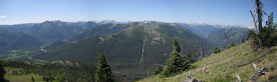
| Loneman is the mountain on the right. Harrison Lake is in the valley left of center. |
Calling out to them I eventually found them even further west of me. They wandered and found (made) a route up a very steep hill. It looked to be the historic river bank from centuries past. They were single file climbing up the hill until they reached the Boundary Trail.
We followed the Boundary Trail east for about a mile until we reached the side trail that went to Harrison Lake.

At the trail junction of the South Boundary Trail and the Harrison Lake Trail we found the old cabin of moonshiner
Josephine Doody. She was a colorful historic character written about in the book, "
Wild River Pioneers".
If I remember the story correctly the passing train engineers would blow their train whistle the number of times to indicate how many jugs of moonshine Josephine was to bring them. She would load the jugs on her boat and cross the river to
meet the train. This was many years ago as I did not see any signs of the river near her cabin now.
 |
| The remains of Josephine Doody's old homestead |
 |
| Josephine Doody's old tractor |
After everyone checked out the cabin ruins we headed to Harrison Lake. Ever since we had crossed the river we were in trees with no views. Occasionally we would pass through burned sections from a forest fire earlier this decade. Patti wasn't happy about the lack of views.
Once we reached the foot of the lake there was no real good place to sit by the lake to eat lunch. I encouraged the group to keep going with the goal of reaching the back county campground near the head of the lake. It was only another 1.9 miles.
Even walking along the lake the views were limited.
 |
| Foot of Harrison Lake |
By the time we reached the campground and saw a beach along the lake shore Patti had had it and declared she was going no further and that she would never do this hike again. I was okay with the lack of views and I continued down the trail.
After a third of a mile or so I came to a back country patrol cabin. It was locked up and no one was there.
The door handle was a curved branch.
I continued on and reached the head of the lake. In this area the trail became a game trail and after a short distance that faded away in the thick brush. Apparently a trail had gone further up the valley but the Park has abandoned it. I've heard the Park used to have over one thousand miles of trails but has abandoned a number of them and now only has seven hundred miles of trails. It seems they are being abandoned not because of lack of money but because the Park wants to manage the Park as wilderness and doesn't want all these trails. Too bad.
A good stream of water entered the head of the lake so there is still plenty of snow up the valley. On the lake shore I found an excellent walking stick and used it to hike back out.
 |
| Head of Harrison Lake |
I stayed at the head of the lake only a short time as the rest of the group may or may not still be at the beach at the campground. Upon my return I found Leah, Amy and Jeanie had come and joined us. Everyone was laying around the beach eating and sunning themselves. Or the women were, as Gene, as usual, was well protected from the sun with his hat, long sleeved shirt and long pants.
Patti, Amy and Leah all had gone for a swim and were drying out as they had swum in most of their clothes. The water was so clear and not cold and I could see where the lake bottom dropped off quickly. Even though I was wearing long pants, the lake looked so inviting I thought about going for a swim. The women all encouraged me to do so. They all said it would be fine if I stripped down to my underwear to go for a swim. They claimed that seeing a guy in his underwear was nothing they hadn't seen before.
Hmmm.... they all seemed a little eager for me to strip down and go for a swim.

I decided to eat my lunch instead. Later when everyone got back together at the cars Patti told the others that all the women went for a swim in the lake but the guys (me and Gene) had chickened out.
Under a clear sky on a perfectly warm day the fine rocks felt just right for laying on. Other than a sightseeing helicopter high above the mountains it was absolutely quiet. We sat and watched the water flow as it passed by. Often fish would jump out of the water and I could see a number - and even a small school at one point - pass by. I found a small fish can make a big splash.
Occasionally butterflies would float just above the water seemingly to dance upon its surface. Patti insisted these were "boy" butterflies and were attacking their reflection not realizing it was of themselves. Then suddenly with a splash one butterfly was gone.
Wow! We then sat and watched another butterfly dancing on the water and waited for a fish to get it also. But luck was with this butterfly as it was halfway across the lake before we all lost interest and quit watching for its demise.
Everyone thoroughly enjoyed their time at the lake and all talked about coming back again. Even Patti changed her mind about the lake and the hike. Well... not completely about the hike as she still thinks it is boring. But she loves the lake.
 |
| Our beach |
During the hike back Patti, Gene and Joyce were in the lead and they all took off. Leah offered to let me by as I was trailing the group. I declined and hiked with her, Amy and Jeanie back to the cars.
Fortunately Patti and Leah had tied some cloth to mark the location where we would leave the Boundary Trail and go back to the river as I would have walked right past it. Jeanie wanted to find another path down to the river as she was concerned about how steep the hillside was. We walked down the trail a short ways but it all looked the same so we returned to the spot we had climbed up.
I went down first, and while steep, it wasn't too bad. Amy was next and after she started she got quite nervous about climbing down. I climbed two-thirds back up and told her to not to go face forward but to back down and use her hands and feet on the slope. She was hesitant to do so as she wanted to look where she was going but with my and Leah's encouragement she turned around and found it was easier to use her hands to hold on to small bushes to help her move down.
After I helped Amy down I watched while Leah then Jeanie came down. Everyone made it down ok. Then it was off through the tall grass underbrush to find the river. We had the advantage of seeing the grass bent over from our earlier hike from the river so we easily found the place where to cross the river. The others were waiting on the other side.
This was the first time Joyce had hiked with Leah's group and she had made and brought her excellent huckleberry dessert for all to share.
Back in Columbia Falls most of us went to the local Mexican restaurant for supper before parting ways.
The sign said the Harrison Lake trail from the Boundary Trail junction to the campground was 4.8 miles. I estimate I hiked at least a half mile past the campground to the head of the lake. I also estimate the distance from the car to the Harrison Creek trail junction was at least a mile and a half. All total I hiked about 14 miles.