Blue skies lead to a blue mood?
Yesterday Joyce and I drove 100 miles and crossed the Continental Divide in search of a blue sky. We found it once we reached Maria Pass. The mountain tops held the clouds back and it was solidly clear and blue to the east.
Sun! Oh, glorious sun!
Around East Glacier everything was coated in a thick frost.
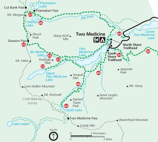
We skied 7 miles to Two Medicine Lake and close to the shadows from the clouds trying to get past the mountains. The wind brought occasional snow flakes flying floating by.
Late afternoon we watched the looming clouds and anticipated the loss of sunlight as we drove back to and under the massive line of clouds. Even after we entered the cloud's shadow we could still see the snow covered mountains to our side lit by the sunlight. Then all traces of sunlight were gone.
Today I have a 'hangover' from my blue sky experience. It is gloomy and gray here yet again for another day and the forecast has this forever. I miss seeing the blue sky.
Tonight there was a story on the local weather forecast that said that the Flathead Valley has had five days of blue skies since December 1. Only five days! Fortunately I spent a few weeks back in Minnesota and North Dakota since December so I saw more than just five days of sun. Still... I want more sun.
It didn't help that Leah forwarded me some photos taken by a friend of hers who hiked up to Mt Brown Lookout last weekend. This hike is on my list of things to do this winter and I haven't made it up there yet.
Showing posts with label XC Skiing. Show all posts
Wednesday, February 10, 2010
Tuesday, February 9, 2010
Two Medicine ski
Tuesday, February 9, 2010 Joyce and I skied to Two Medicine Lake. We liked the idea of visiting the lake in the Winter, but mainly we were looking for blue skies. The Flathead Valley had only 5 full days of sun since December 1.

Once we reached Marias Pass on the Continental Divide the clouds ended and it was nothing but blue skies ahead. Around East Glacier everything was white, having been covered by thick frost.
Once we had crossed the Continental Divide there was hardly any snow. We had hoped to ski but also brought snowshoes and hiking boots for whatever the conditions were. It can get windy in the Two Medicine Valley and we expected most of the snow to be blown off the road. To our surprise we could only drive a half mile off of Hwy 49 on the road to Two Medicine. Any more would be risking it - and Joyce didn't bring a shovel along in her car. Probably a quarter mile down the road was the furthest any vehicle had traveled. Judging from the broken pine branches they must have used them for traction in helping them get unstuck.
At the end of the afternoon when we returned to the car we saw fresh tracks. That vehicle didn't go as far as seen in the above photo before they wised up and turned around.
Our destination is to the left of the leftmost white mountain (Rising Wolf Mountain) in the distance. We had already skied a half mile to a mile when I took this photo. Lower Two Medicine Lake is in the foreground.
There were plenty of ski tracks in the snow. And some foot prints. The snow depth varied from a small amount to deep. When the snow was deep the footprints sunk deep even though the person tried to walk in various ski tracks. The further we went the less tracks. By the time we reached the Glacier Park gate only a few tracks were left.
Shortly after we entered the park the snow disappeared from the road and we had to ski in the ditch. By now there was only one set of ski tracks. The bare road last several miles. The ski tracks turned around short of the return of the road snow. If they had only gone around one more bend in the road...
We skied the .3 mile to see Running Eagle Falls. I was able to ski relatively close to the falls. I even skied/climbed up to the observation platform and back down without falling into the water. In fact I didn't crash once on this trip. The snow was good for skiing. The temperature was in the 20s so the snow wasn't sticky. And there was enough to ski on but not too much to slow one down as I had to break trail.
In the summer water also flows over the top.


The wind wasn't too bad and probably was blowing only 10 to 15 mph. At times we were completely sheltered from the wind. At Two Medicine Lake we felt the wind's cold bite as we ate our lunches.
Skiing back to the car we had the wind at our back - and that was nice.
-

Once we reached Marias Pass on the Continental Divide the clouds ended and it was nothing but blue skies ahead. Around East Glacier everything was white, having been covered by thick frost.
Once we had crossed the Continental Divide there was hardly any snow. We had hoped to ski but also brought snowshoes and hiking boots for whatever the conditions were. It can get windy in the Two Medicine Valley and we expected most of the snow to be blown off the road. To our surprise we could only drive a half mile off of Hwy 49 on the road to Two Medicine. Any more would be risking it - and Joyce didn't bring a shovel along in her car. Probably a quarter mile down the road was the furthest any vehicle had traveled. Judging from the broken pine branches they must have used them for traction in helping them get unstuck.
At the end of the afternoon when we returned to the car we saw fresh tracks. That vehicle didn't go as far as seen in the above photo before they wised up and turned around.
Our destination is to the left of the leftmost white mountain (Rising Wolf Mountain) in the distance. We had already skied a half mile to a mile when I took this photo. Lower Two Medicine Lake is in the foreground.
There were plenty of ski tracks in the snow. And some foot prints. The snow depth varied from a small amount to deep. When the snow was deep the footprints sunk deep even though the person tried to walk in various ski tracks. The further we went the less tracks. By the time we reached the Glacier Park gate only a few tracks were left.
Shortly after we entered the park the snow disappeared from the road and we had to ski in the ditch. By now there was only one set of ski tracks. The bare road last several miles. The ski tracks turned around short of the return of the road snow. If they had only gone around one more bend in the road...
We skied the .3 mile to see Running Eagle Falls. I was able to ski relatively close to the falls. I even skied/climbed up to the observation platform and back down without falling into the water. In fact I didn't crash once on this trip. The snow was good for skiing. The temperature was in the 20s so the snow wasn't sticky. And there was enough to ski on but not too much to slow one down as I had to break trail.
In the summer water also flows over the top.
![]() |
| Running Eagle Falls |

![]() |
| Spot Mountain |
The view to the valley that leads to Pitamakan Pass.
Rising Wolf Mountain is on the left and Spot Mountain is on the right.
![]() |
| The road looks more level that it actually is. |
![]() |
| This mountain is the location of the trail to Scenic Point. |
![]() |
| The campground is Full?!!! |

![]() |
| Rising Wolf Mountain. |
![]() |
| Two Medicine Lake and Sinopah Mountain. |
The wind wasn't too bad and probably was blowing only 10 to 15 mph. At times we were completely sheltered from the wind. At Two Medicine Lake we felt the wind's cold bite as we ate our lunches.
![]() |
| Sinopah Mountain |
Skiing back to the car we had the wind at our back - and that was nice.
-
Labels:
Glacier,
Joyce,
Lakes,
Two Medicine area,
XC Skiing
Sunday, January 31, 2010
Got outside for some fun in Glacier
I finally got outside for some fun this Winter. Thursday I cross country skied 11 miles on the Old Ranger Station trail in Glacier Park and Saturday I hiked to Snyder Lake (9 miles round trip and again in Glacier Park). Yes, I said 'hiked'. While I brought my snowshoes along I didn't need them as the trail was packed down to hard snow. On some parts of the trail, stepping "off trail" meant sinking into snow up to my knees, and in one case almost to my waist.
Late Saturday night and Sunday it snowed. Officially at the airport we had 1.3 inches of snow. But at my place I am sure we had closer to 3 inches. Anyway, the new snow made it pretty and white again, as with no wind, the snow fell straight down and blanketed everything.
Here is the view of Lake McDonald when I hiked Saturday.
Labels:
Glacier,
Hiking,
Lake McDonald area,
Lakes,
XC Skiing
Thursday, January 28, 2010
Old Flathead Ranger Station xc ski
Thursday, January 28, 2010, Joyce, Kendra, Greg and I cross country skied on the Old Flathead Ranger Station trail in Glacier Park.
This was the first time I got out this Winter for either skiing or hiking. It hasn't been much of a Winter for snow but I found the snow on this trail was ok for skiing. It wasn't fresh, but also not crusty or icy.
The road to the trail head was closed near the horse corrals and we had to ski about a mile to the trail head. The Flathead Ranger Station trail is near the Apgar Lookout trail.
We saw Apgar Mountain as we skied to the trail head.
We skied over the bridge where McDonald Creek enters the Middle Fork of the Flathead River.
Once we were on the Ranger Station trail we began to encounter fallen trees across the trail. This area had been burnt in the 2003 Robert Fire. The Park left the burnt trees and over time they fall. Because this is a popular trail for cross country skiing and snowshoeing, I feel the park should have gone over the trail one last time in the Fall to clear the trees that had fallen across the trail.
While not steep hills, the trail had hills nonetheless. Skiing down them was a challenge due to the lack of snow for snowplowing, curves, and the occasional fallen tree across the road. I think I crashed at least once on each long downhill. I had carried my camera in my right rear pants pocket and after a couple falls - each fall landing me on my right side - I moved the camera to my left pocket. The snow was relatively soft but I was taking no chances with my camera. My last fall was on hard packed snow so I was happy I had moved my camera.
We had to take off our skis to get down a steep hill to cross a creek. On the return trip the bindings on one of my skis had froze and for a while it looked like I may have to go up and down the steep hills on one ski.
I had hiked this trail in the past and never saw signs of the location of the old ranger station. Naturally under the snow I didn't see signs this time either.
I did see lots of animal tracks. Elk tracks and dropping were common. I also saw signs of several perhaps coyote tracks. Dogs are not allowed in the Park and the Flathead River and the remote location reduced chances that dogs would come here on their own.
We skied along the Middle Fork of the Flathead River.
We skied all the way to the North Fork of the Flathead River where it joined the Middle Fork of the Flathead. At the steep bank overlooking the North Fork I found what looked to be the same trees eroding and overhanging the river bank as when I was last here in 2006.
In the sun's warmth small rocks were loosened from the river bank and rolled noisily down, many to the river. Probably not a good idea to stand close to the edge to look at eroded trees.
As began to ski back we saw a guy down below skiing on the south side of the Middle Fork of the Flathead. With the water level low he was able to ski on the snow covered parts of the dry side of the river bed. That didn't last too long as in less than a quarter to half mile there were no more areas to ski in the river channel.
While we had only skied 11 miles Kendra was exhausted by the time we got back to Joyce's car. Kendra and Greg haven't skied with us since.
This was the first time I got out this Winter for either skiing or hiking. It hasn't been much of a Winter for snow but I found the snow on this trail was ok for skiing. It wasn't fresh, but also not crusty or icy.
The road to the trail head was closed near the horse corrals and we had to ski about a mile to the trail head. The Flathead Ranger Station trail is near the Apgar Lookout trail.
We saw Apgar Mountain as we skied to the trail head.
![]() |
| Apgar Mountain |
We skied over the bridge where McDonald Creek enters the Middle Fork of the Flathead River.
Once we were on the Ranger Station trail we began to encounter fallen trees across the trail. This area had been burnt in the 2003 Robert Fire. The Park left the burnt trees and over time they fall. Because this is a popular trail for cross country skiing and snowshoeing, I feel the park should have gone over the trail one last time in the Fall to clear the trees that had fallen across the trail.
New and old life after the Robert Fire.
While not steep hills, the trail had hills nonetheless. Skiing down them was a challenge due to the lack of snow for snowplowing, curves, and the occasional fallen tree across the road. I think I crashed at least once on each long downhill. I had carried my camera in my right rear pants pocket and after a couple falls - each fall landing me on my right side - I moved the camera to my left pocket. The snow was relatively soft but I was taking no chances with my camera. My last fall was on hard packed snow so I was happy I had moved my camera.
We had to take off our skis to get down a steep hill to cross a creek. On the return trip the bindings on one of my skis had froze and for a while it looked like I may have to go up and down the steep hills on one ski.
I had hiked this trail in the past and never saw signs of the location of the old ranger station. Naturally under the snow I didn't see signs this time either.
I did see lots of animal tracks. Elk tracks and dropping were common. I also saw signs of several perhaps coyote tracks. Dogs are not allowed in the Park and the Flathead River and the remote location reduced chances that dogs would come here on their own.
We skied along the Middle Fork of the Flathead River.
We skied all the way to the North Fork of the Flathead River where it joined the Middle Fork of the Flathead. At the steep bank overlooking the North Fork I found what looked to be the same trees eroding and overhanging the river bank as when I was last here in 2006.
In the sun's warmth small rocks were loosened from the river bank and rolled noisily down, many to the river. Probably not a good idea to stand close to the edge to look at eroded trees.
As began to ski back we saw a guy down below skiing on the south side of the Middle Fork of the Flathead. With the water level low he was able to ski on the snow covered parts of the dry side of the river bed. That didn't last too long as in less than a quarter to half mile there were no more areas to ski in the river channel.
While we had only skied 11 miles Kendra was exhausted by the time we got back to Joyce's car. Kendra and Greg haven't skied with us since.
Friday, March 27, 2009
March skiing
Friday March 27 I went cross country skiing with Joyce, Kendra and Greg. The end of March is getting late in the season to be skiing but there was still plenty of snow in the foothills where we skied. Which was... on the way to Jewel Basin in the Swan Range.
The snow was crunchy and a little slick but still decent for skiing. We had old ski tracks to follow and I found they were a touch narrow. At times I could feel the crunchy snow rub the sides of my shoes. When I wasn't in the tracks sometimes that worked well if I was able to make new tracks, and other times not so good as I skittered across the top of the hard snow that was wavy from drifting. The temperature this day barely got above freezing so the snow remained hard all day.
Even though it was near where Greg and Kendra live, they hadn't skied there. In the past they had just noticed cars with some skis parked along the road to Camp Misery. When we arrived there were no cars (after all this was a week day) and the parking area was a large lightly frozen water puddle. We didn't see tracks or an obvious place to ski to the south of the road so we drove onward. And upward.
The road went upward and had more and more snow as we continued onward. Pickups had driven this when the weather was warmer and the single lane road had wheel ruts. Joyce's car is a two-wheel drive and not so high, so we decided to turn around when we came to a small area with enough room to do so.
Back at the "water puddle" we checked the north side of the road and saw a gate and ski tracks. We got our skis on and away we went.
The area is state land that had been partially logged. We followed a large loop in a clockwise manner. The terrain was mainly flat with a few hills that we had to go down. Carefully, as the snow did not allow for snowplowing or steering.
Here part of the snow melted and I had to thread my way along this bank to get down to Greg and Kendra below.

Even though the old ski tracks did not go into side trails we went down a couple of them and discovered: dead ends.
Greg and Kendra's dog, Max, joined us. Max would also lead the way even though I skied in the lead and Greg and Kendra were further behind me.
For some strange reason we ran across several child toys along the way partially buried in the snow.
The 'return' part was south along the road and we decided to take a side trail (that had ski tracks) away from the road. This side trail led us around and back into the north side of the loop. We had to backtrack most of the way towards the road until we got to new growth where we had room to ski through the trees. We made our own trail until we reconnected to the outer loop trail.
Along the way one of Joyce's ski poles broke. I suggested breaking a length of a dead branch and she used that to help her ski back to the car. Here Joyce is holding her good and bad ski poles in her right hand and the branch in her left.

We skied for two hours and twenty minutes so I estimate we had skied four miles.
After we finished skiing we returned to Greg and Kendra's home for a delicious meal of lasagna, sandwiches, humus and conversation.
The snow was crunchy and a little slick but still decent for skiing. We had old ski tracks to follow and I found they were a touch narrow. At times I could feel the crunchy snow rub the sides of my shoes. When I wasn't in the tracks sometimes that worked well if I was able to make new tracks, and other times not so good as I skittered across the top of the hard snow that was wavy from drifting. The temperature this day barely got above freezing so the snow remained hard all day.
Even though it was near where Greg and Kendra live, they hadn't skied there. In the past they had just noticed cars with some skis parked along the road to Camp Misery. When we arrived there were no cars (after all this was a week day) and the parking area was a large lightly frozen water puddle. We didn't see tracks or an obvious place to ski to the south of the road so we drove onward. And upward.
The road went upward and had more and more snow as we continued onward. Pickups had driven this when the weather was warmer and the single lane road had wheel ruts. Joyce's car is a two-wheel drive and not so high, so we decided to turn around when we came to a small area with enough room to do so.
Back at the "water puddle" we checked the north side of the road and saw a gate and ski tracks. We got our skis on and away we went.
The area is state land that had been partially logged. We followed a large loop in a clockwise manner. The terrain was mainly flat with a few hills that we had to go down. Carefully, as the snow did not allow for snowplowing or steering.
Here part of the snow melted and I had to thread my way along this bank to get down to Greg and Kendra below.

Even though the old ski tracks did not go into side trails we went down a couple of them and discovered: dead ends.
Greg and Kendra's dog, Max, joined us. Max would also lead the way even though I skied in the lead and Greg and Kendra were further behind me.
For some strange reason we ran across several child toys along the way partially buried in the snow.
The 'return' part was south along the road and we decided to take a side trail (that had ski tracks) away from the road. This side trail led us around and back into the north side of the loop. We had to backtrack most of the way towards the road until we got to new growth where we had room to ski through the trees. We made our own trail until we reconnected to the outer loop trail.Along the way one of Joyce's ski poles broke. I suggested breaking a length of a dead branch and she used that to help her ski back to the car. Here Joyce is holding her good and bad ski poles in her right hand and the branch in her left.

We skied for two hours and twenty minutes so I estimate we had skied four miles.
After we finished skiing we returned to Greg and Kendra's home for a delicious meal of lasagna, sandwiches, humus and conversation.
Our skiing view of the Swan Range.
Sunday, March 8, 2009
Camas Road ski
Sunday afternoon, March 8, Patti showed up at my door to ask if I wanted to go skiing with her. Even though it was snowing and blowing outside and somewhat storming, how could I say no?
I grabbed my skis and a few items and off we went in her four-wheel drive Suburu. The roads were snow covered and the traffic was light. East of Columbia Falls we encountered a brief whiteout condition as the strong winds blew lots of snow across the road. Once we got through Badrock Canyon the wind subsided and we could see better.
We first stopped at a place, near the KOA campground, along Hwy 2 where Patti likes to ski. I am not sure if it was state or federal land but it had a trail looping though the trees. Two vehicles were parked at the entrance and we found fresh ski tracks and next to those, fresh snowshoe tracks. The vehicles were gone when we got back to Patti's car and in their place was a woman preparing to go skiing.
The loop took us less than 45 minutes and I estimate it was about 2 miles long.
We then headed to Glacier Park to ski on the Camas Road.
At the gate to Camas Road we found one set of ski tracks in the new snow. Patti and I skied to McGee Meadow and the tracks went beyond that so we assume the skier skied the entire distance from the North Fork Road to the gate, a distance of about 12 miles.

It was a long slog up to the top of Camas Road. This was all the further Patti had skied in the past but I encouraged her to ski to McGee Meadow. It is only six miles... one way.
I hadn't skied there from this direction so several times I thought it was "just around the bend" when it wasn't.

Along the way we had live trees and we had dead trees. These dead trees were from the Robert fire back in 2003.

We made it all the way to McGee Meadow. After talking a few photos of us with the meadow and mountains in the background we headed back to the car. I had snow over a good part of me as I had fallen over when getting ready to take Patti's photo.

Patti was ahead of me as I stopped to take photos along the way. During the long downhill she stopped and waited for me. In the twilight she had seen a large animal up ahead on the road. We had seen plenty of moose tracks earlier but Patti wanted to make sure it was not a bear who had woken up from a hibernation. I skied ahead to get a closer look. The animal saw us and heard Patti calling out warnings to me. It turned and went back into the trees from whence it came. When we got to where it had been the tracks appeared to be moose tracks. No bear. Patti was pleased as she hadn't brought her bear spray.
As we skied on we kept an eye out in case the moose came back out and charge us. It didn't.
Not to say it was quiet in the deep snow and under the moonlight. With the setting of the sun the temperature dropped. As we skied we could hear crack!... Crack!... CRACK! to our right in the trees. We looked and looked searching for the moose or a bear or whatever moving through the trees. Then nothing. Then more cracking sounds. What is it?! A bit later I heard the cracking sounds on our left. Eventually I decided the cracking sounds were the trees as the temperature quickly dropped. What else could it have been?
The moon rose NE over the mountains and Lake McDonald. So beautiful.
Onward we skied. To keep warm and to get back to the car before it got too dark.

We did stay warm as we skied. But the dark caught up to us before we reached Patti's car.
Order of business (to be completed as quickly as possible!):
I grabbed my skis and a few items and off we went in her four-wheel drive Suburu. The roads were snow covered and the traffic was light. East of Columbia Falls we encountered a brief whiteout condition as the strong winds blew lots of snow across the road. Once we got through Badrock Canyon the wind subsided and we could see better.
We first stopped at a place, near the KOA campground, along Hwy 2 where Patti likes to ski. I am not sure if it was state or federal land but it had a trail looping though the trees. Two vehicles were parked at the entrance and we found fresh ski tracks and next to those, fresh snowshoe tracks. The vehicles were gone when we got back to Patti's car and in their place was a woman preparing to go skiing.
The loop took us less than 45 minutes and I estimate it was about 2 miles long.
We then headed to Glacier Park to ski on the Camas Road.
At the gate to Camas Road we found one set of ski tracks in the new snow. Patti and I skied to McGee Meadow and the tracks went beyond that so we assume the skier skied the entire distance from the North Fork Road to the gate, a distance of about 12 miles.

It was a long slog up to the top of Camas Road. This was all the further Patti had skied in the past but I encouraged her to ski to McGee Meadow. It is only six miles... one way.
I hadn't skied there from this direction so several times I thought it was "just around the bend" when it wasn't.

Along the way we had live trees and we had dead trees. These dead trees were from the Robert fire back in 2003.

We made it all the way to McGee Meadow. After talking a few photos of us with the meadow and mountains in the background we headed back to the car. I had snow over a good part of me as I had fallen over when getting ready to take Patti's photo.

Patti was ahead of me as I stopped to take photos along the way. During the long downhill she stopped and waited for me. In the twilight she had seen a large animal up ahead on the road. We had seen plenty of moose tracks earlier but Patti wanted to make sure it was not a bear who had woken up from a hibernation. I skied ahead to get a closer look. The animal saw us and heard Patti calling out warnings to me. It turned and went back into the trees from whence it came. When we got to where it had been the tracks appeared to be moose tracks. No bear. Patti was pleased as she hadn't brought her bear spray.
As we skied on we kept an eye out in case the moose came back out and charge us. It didn't.
Not to say it was quiet in the deep snow and under the moonlight. With the setting of the sun the temperature dropped. As we skied we could hear crack!... Crack!... CRACK! to our right in the trees. We looked and looked searching for the moose or a bear or whatever moving through the trees. Then nothing. Then more cracking sounds. What is it?! A bit later I heard the cracking sounds on our left. Eventually I decided the cracking sounds were the trees as the temperature quickly dropped. What else could it have been?
The moon rose NE over the mountains and Lake McDonald. So beautiful.
Onward we skied. To keep warm and to get back to the car before it got too dark.

We did stay warm as we skied. But the dark caught up to us before we reached Patti's car.
Order of business (to be completed as quickly as possible!):
- take off our skis
- start the car
- turn the car's heater on
- toss the skis and stuff into the car
- take this photo
- jump into the car
Saturday, March 7, 2009
Strawberry Lake Road ski
Saturday, March 7 I skied with Joyce, Kendra, and Greg on forest service road 5390 that goes to the trail head for Strawberry Lake in the Jewel Basin. Apparently our jaunt to Bowman Lake earlier in the week didn't scare off Kendra and Greg from skiing with Joyce and I.
Kendra and Greg live a short distance from where we skied and know the area.
The forest service road is closed for the winter to vehicles which made it perfect for skiing. We had gotten a few inches of snow a few days earlier so we had fresh snow to ski on. The new snow depth wasn't much and the snow was slippery/fast in some areas. Also the road was not flat for the most part as much of it went consistently up, though at a mostly reasonable rate.
Along the way we saw a tree whose bark had been clawed off by a bear.

We met a young couple who were returning. The man was pulling a green plastic sled which was fully enclosed. A very young child - almost a baby - was inside and sleeping soundly. The man pulling the sled was getting a workout!
The young couple didn't go all the way to the end of the road as I noticed from their ski tracks they had turned around a half mile or so from the end when the road got steeper. We were then the only tracks as we continued on to the end.
Greg and Kendra brought their dog, Max, with us.

At the end of the road the trail to Strawberry Lake began with a simple bridge over a creek. I had been here once before in the 1990s when I hiked up to Strawberry Lake on this trail.
On the way back I did well skiing down the steeper sections and turns and only did one or two controlled crashes where I couldn't get turned correctly and at that speed was heading to go off the trail and into the trees.
Once I got to the less steep areas I was skiing slowly when I crashed. Sure, I make it down the steep sections and crash when it got easier.
This fall has me tangled and my shoe came off the ski. Earlier that week I had fallen over and cracked the sole of my left shoe. Now the part of the sole from the crack under the ball of my foot to the front came off the shoe. 
When I crashed I almost got run over as Joyce and Kendra were close behind me. I moved and they moved just enough that they got by. Greg ended up crashing.
Unlike the previous time where my right shoe's sole came off I wasn't unable to clip my shoe into the ski. The skis I was using were Bill's and they had a slightly different hold mechanism for the shoe and I couldn't pinch the front of my shoe into the ski.
I had two miles left to ski down hill. I had no choice but to try to ski by placing my shoe on the ski without locking it in. In effect skiing on one and a half skis.
For the most part this worked. However when I encountered rough snow this would cause the ski to leave my foot. Then one time there was a patch of ground and my ski suddenly stopped while I kept going. *crash*
Other than the young couple we saw earlier the only other people we met was a guy on a snowmobile pulling another guy on skis up the road. Naturally I had to meet them when I was pretty much skiing on one ski. Thankfully I was able to stay to one side of the road as we passed each other.
I made it down the mountain but I tell you it was harder than skiing up!
I made it to the parking lot well before the others. How did that happen? "Watch out! Crazy guy on one ski coming through!"
While waiting for the others I noticed a car with a large bumper sticker on the driver's door. I liked the sticker though I wouldn't have placed it on my car door.

After we finished skiing we returned to Greg and Kendra's home to have a meal and chat. They had canned antelope they had made and this made excellent sandwiches along with brussel sprouts.
Kendra and Greg live a short distance from where we skied and know the area.
The forest service road is closed for the winter to vehicles which made it perfect for skiing. We had gotten a few inches of snow a few days earlier so we had fresh snow to ski on. The new snow depth wasn't much and the snow was slippery/fast in some areas. Also the road was not flat for the most part as much of it went consistently up, though at a mostly reasonable rate.
Along the way we saw a tree whose bark had been clawed off by a bear.

We met a young couple who were returning. The man was pulling a green plastic sled which was fully enclosed. A very young child - almost a baby - was inside and sleeping soundly. The man pulling the sled was getting a workout!
The young couple didn't go all the way to the end of the road as I noticed from their ski tracks they had turned around a half mile or so from the end when the road got steeper. We were then the only tracks as we continued on to the end.Greg and Kendra brought their dog, Max, with us.

At the end of the road the trail to Strawberry Lake began with a simple bridge over a creek. I had been here once before in the 1990s when I hiked up to Strawberry Lake on this trail.
On the way back I did well skiing down the steeper sections and turns and only did one or two controlled crashes where I couldn't get turned correctly and at that speed was heading to go off the trail and into the trees.
Once I got to the less steep areas I was skiing slowly when I crashed. Sure, I make it down the steep sections and crash when it got easier.
This fall has me tangled and my shoe came off the ski. Earlier that week I had fallen over and cracked the sole of my left shoe. Now the part of the sole from the crack under the ball of my foot to the front came off the shoe. 
When I crashed I almost got run over as Joyce and Kendra were close behind me. I moved and they moved just enough that they got by. Greg ended up crashing.
Unlike the previous time where my right shoe's sole came off I wasn't unable to clip my shoe into the ski. The skis I was using were Bill's and they had a slightly different hold mechanism for the shoe and I couldn't pinch the front of my shoe into the ski.
I had two miles left to ski down hill. I had no choice but to try to ski by placing my shoe on the ski without locking it in. In effect skiing on one and a half skis.
For the most part this worked. However when I encountered rough snow this would cause the ski to leave my foot. Then one time there was a patch of ground and my ski suddenly stopped while I kept going. *crash*

Other than the young couple we saw earlier the only other people we met was a guy on a snowmobile pulling another guy on skis up the road. Naturally I had to meet them when I was pretty much skiing on one ski. Thankfully I was able to stay to one side of the road as we passed each other.
I made it down the mountain but I tell you it was harder than skiing up!
I made it to the parking lot well before the others. How did that happen? "Watch out! Crazy guy on one ski coming through!"
While waiting for the others I noticed a car with a large bumper sticker on the driver's door. I liked the sticker though I wouldn't have placed it on my car door.

After we finished skiing we returned to Greg and Kendra's home to have a meal and chat. They had canned antelope they had made and this made excellent sandwiches along with brussel sprouts.
Labels:
Jewel Basin,
Joyce,
Swan Mountain Range,
XC Skiing
Subscribe to:
Posts (Atom)